- Bike: mtb
- Difficulty: ***
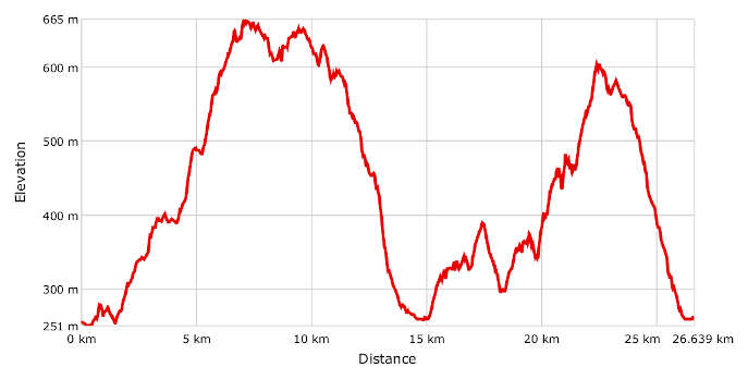
- Distance: 27 km
- Altitude difference: 414 m
- Total ascent: 1002 m
- Total descent: 999 m
Merana is a small town in Alto Monferrato on the border with the Liguria region, in the province of Savona, at the foot of the Piedmont Apennines. The geological evolution of these regions took place about 35 to 5 million years ago and is connected to the Paleo-Adriatic Sea. The Sea filled what is now the Po Valley and lapped the shores of the Piedmont valleys in what were dramatically different geographical surroundings.
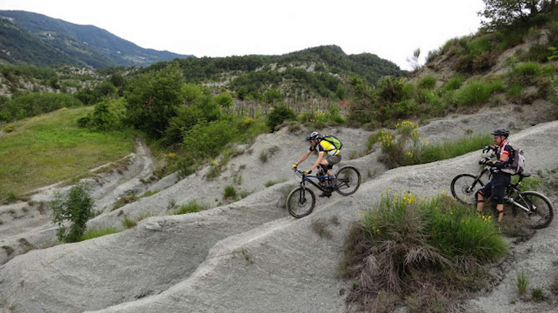
Country roads and trails, their natural beauty preserved, unwind on ridges and gullies, along the bottom of the valley and in avalanche chutes. Today, these paths are the ideal terrain for mountain bike lovers.
The itineraries crossing the hilly landscape of Merana are truly unique: cycling over the gullies is a remarkable experience that requires great technique and training. The route will give you the chance to discover the erosive shapes sculpted into the ancient seabed, the so-called "muriòn", mysterious stone figures that succeed one another among brooms and thyme.
Start in the centre of Merana and follow the red-and-white trail marks. You quickly start climbing towards the marls of the Rocchetta Formation and the natural tower of Merana, with its fascinating gullies. Marl sediments give way to what is the Monesiglio Formation, made of coarse yellow and reddish sands mixed with big arenaceous nodules. Here the landscape turns into a peculiar rock garden, from which rise weird and wonderful shapes: large frogs, crocodiles' heads, sphinxes' bodies. They are the result of selective erosion, which spared the arenaceous nodules, harder than their surrounding sand, creating what could be taken for genuine sculptures: the so-called "muriòn", a dialect term originating from muròn, "large face", and riònd , "round".
This itinerary will teach you some of the geological history of the region and, more generally, will let you experience the history, botany and local dishes of the Monferrato area. Start in Merana, from the car park in front of the Proloco office, in Località Gilarda, and head towards town by passing in front of the imposing church of Santa Maria Assunta. Just before the railway, turn left towards Località Pere. Here you begin the first stretch of a climb that will continue for about 7 km.
Once at the crossroads turn right, following the signs for Località Scabaggio where, following the GPX track, you cross a field and soon after a small wood, reaching a small tarmac road. Turn right onto it and follow it for about 100 m before turning left on a path identified by CAI (Italian Alpine Club) marks. After 3 km, this beautiful wooden path reaches the gully area. The path on the cliffs is very clear to see, with scenic stretches, deserted but for a cyclist or two. Once on the "Cima Coppi" of this tour, the highest point at 665 m, return to civilisation along the SP 218 where, after turning left, you pass the small, abandoned Romanesque church of San Sebastiano, on your right. Continue towards Serole and at the first crossroads turn left towards the Shrine of the Todocco. After about 2.5 km, turn left and admire the breathtaking views that open up from the ridge of the hill. A long descent along the paths, across a muriòn and gully area, takes you back to Merana. Go past the Proloco once more, this time in the opposite direction, cross another gully area and cruise along an easy small scenic road, among rocks, woods and vineyards.
Once you reach Correnti, hamlet of Spigno Monferrato, turn left and take a cart track among the gullies, to the Bertolotto farm: a nice uphill path in the woods takes you to the gravel road you were on before, when going in the opposite direction.
At the crossroads, turn left. The descent starts here, through another muriòn and gully area and to the hamlet of Ghioni. The tour ends where it previously started, at the Proloco of Merana.