- Bike: mtb
- Difficulty: ***
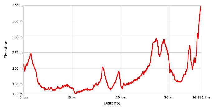
- Distance: 37 km
- Altitude difference: 280 m
- Total ascent: 751 m
- Total descent: 567 m
The Alessandro Davite Trail (named in memory of the late member of CAI San Salvatore), and marked by signs with the initials MPC (Madonna del Pozzo-Crea), connects the shrine of the Madonna del Pozzo in San Salvatore Monferrato and the shrine of Sacro Monte di Crea at Serralunga di Crea. It's 36.5 km long and includes paths no. 602 and 727, marked by CAI with red-white-red signs.
Every year on 25 April, the San Salvatore branch of CAI organises a hike, usually attended by dozens of walkers. Here you find the same route used for the hike, but for mountain bikes. To reach the shrine of the Madonna del Pozzo, start in the middle of San Salvatore Monferrato and follow the signs towards the hamlet of Frescondino, which soon appears on your left.
From the shrine of the Madonna del Pozzo, follow the route across the field and past a pile of bricks by the memorial to Alessandro Davite. Take a small downhill road and follow it to the barrier, where you take the uphill gravel road on the left.
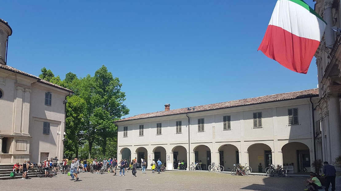
After meeting the SP 64, the path turns left once more, towards the town of San Salvatore. After 500 m turn right (onto Via San Vincenzo), approaching a big building, then turn right again, following the signs for the Paleologi tower. The park surrounding the tower has a rest area and a play area, and from there you can enjoy beautiful views of the area.
The route goes down on the right on Via Sottotorre and right again to the provincial road for Mirabello. Soon after you approach the cemetery, where the tarmac gives way to a small gravel road along the cemetery wall. Keep on following the small road and turn left at the crossroads; you will soon reach the Alessandria-Casale Monferrato state road.
Cross the tarmac and continue onto the country road opposite. After a few metres, turn right and keep on going along, parallel to the main road and by an old shooting range. Once on the municipal tarmac road, turn left towards Valdolenga, go past some houses and the motorway and you will find yourself back on the gravel road. Past the farm Cascina Gibellina and take a right at the crossroads. Soon after, turn left on a country road, then go straight until you cross the Mirabello-Lu provincial road, close to the old kiln. Follow the path past Cascina Campostrina, turn left onto the tarmac road and follow it for about 400 m.
Go straight on at the crossing, onto a wide gravel road, passing Cascina Albareto, and you will see the church of San Giovanni in Mediliano. Go left and then immediately right onto a small dirt road, reaching a small bridge over the Grana stream, where trail no. 727 starts.
Follow the cart track, to a gravel byway that turns left and winds along the bottom of the valley, through the small hills of Lu and Conzano. Go past the provincial road that connects the two towns, continue on the gravel road at the bottom of the valley, turn right at the next crossroads and then continue on tarmac, heading up to the Conzano-Camagna provincial road, near Camagna.
Once you're on tarmac, turn right and then immediately left, onto the Casale-Alessandria provincial road. On the SP 50, go left for a few metres and then take a right towards Frassinello Monferrato.
Continue uphill on tarmac and turn right immediately after the castle of Lignano, near Cascina Nuova, onto the cart track down to the bottom of the valley. The road becomes gravelly and reaches the SP 42, where you turn right and, after 10 m, left, towards Cascine Bellero.
Continue on the cart track, between a fence and a small side chapel, along the bottom of the valley, until you cross a country road, on which you turn right; this is trail no. 746. Soon after, turn left into the Frati valley and reach a crossroads clearly showing how trail no. 727 turns right here, leaving trail no. 746.
Our route continues uphill, until you turn right onto tarmac, close to the town of Ottiglio. After about 100 m, turn left for a brief stretch on the provincial road, then left again towards Cascina Spinosa Alta.
After a few metres the route turns right and goes first downhill and then uphill for a long stretch, reaching the Cascina Spinosa Alta, where it turns sharply left onto a cart track. Follow it across some woods and go straight on at the next crossroads. When you reach a gravel road, turn right and continue past Cascina Spinosa Bassa to a tarmac road, where you turn left: Here the route follows trail no. 747 for a brief stretch.
Once you're on the Casale Monferrato-Moncalvo state road, turn left and after a few metres take the gravel byway on the right, near a big old shed. Keep on going past a level crossing, then turn right and immediately left, following the road at the bottom of the valley, which becomes gravelly and starts going uphill towards Salabue.
You will be on tarmac for a few metres, then take the downhill path past the cemetery (where there is a small fountain to stock up on water). Note that it gets muddy in rainy weather. Go over a ditch then take a track suitable for vehicles. Keep left at the votive shrine and continue straight until you reach the tarmac, close to Forneglio. Turn left onto the tarmac and after a few metres take a very narrow lane between houses, turn left again until you re-emerge on the provincial road, where you turn left once more. The route continues on the tarmac road until the next bend, where you take the path with wide steps that climbs up the sacred mount and finally reaches, after a left turn, the square where the shrine of Crea stands.