- Bike: strada/trekking
- Difficulty: ****
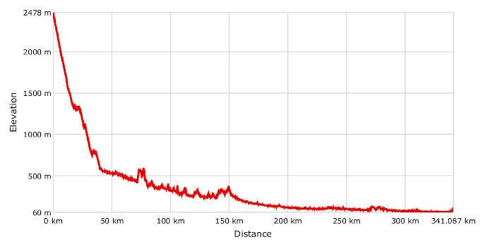
- Distance: 340 km
- Altitude difference: 2418 m
- Total ascent: 2485 m
- Total descent: 4878 m
Since the early Middle Ages, pilgrims from central and northern Europe have been walking the 1,600 km Via Francigena trail to reach Rome, for them the heart of Christianity. In the year 990, Sigeric received his archbishop’s pallium in Rome and described his journey on the trail back to Canterbury, which took 79 days. His diary is the most authentic account of the trail, which in 2004 was declared a 'Cultural Route' by the Council of Europe, along with the Way of St James in Spain.
True pilgrims, either walking or cycling, carry a special pilgrim passport, to distinguish themselves from ordinary travellers. It states the pilgrim's identity and the direction of travel, and records the places they've already visited. It must be issued by a religious authority: in Italy, Confraternita di San Jacopo di Compostella. There are no costs involved, but if you ask for the passport you must also acknowledge its spiritual meaning and plan a journey informed by self-restraint, sharing hostel rooms as well as religious sensibility.
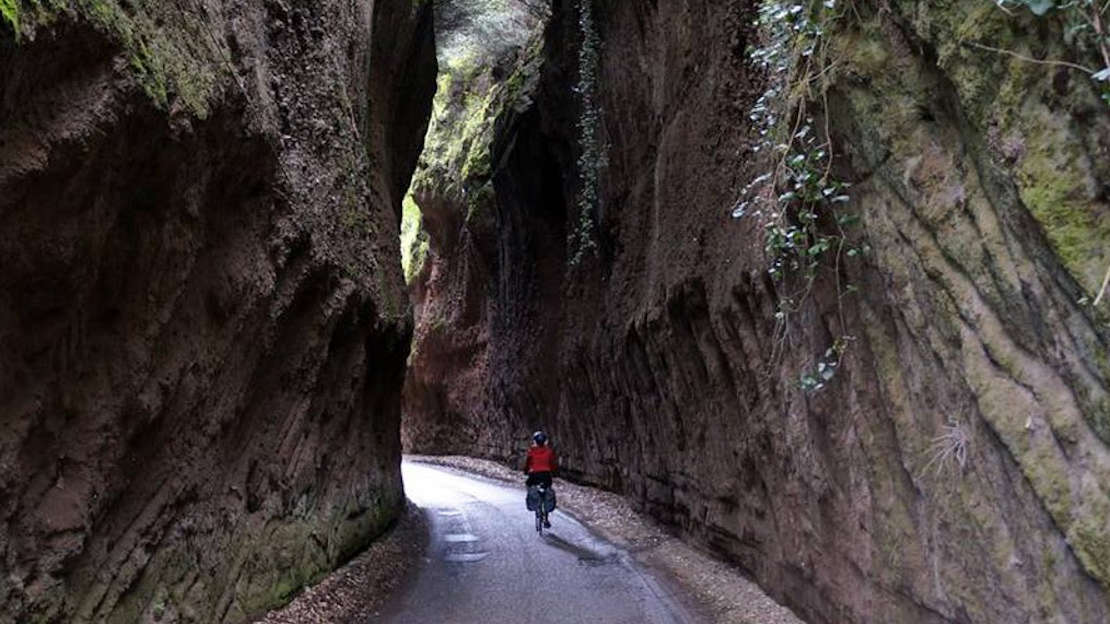
The route follows minor roads, with many stretches on gravel. We therefore advise you to use a bike appropriate for off-road cycling and equipped for travelling.
If you wish to start the trip from the Great St Bernard Pass, reaching Aosta by train, the website www.savda.it offers information about local public transport. According to the site: 'Transporting bicycles is permitted, where possible, by purchasing a half-price single ticket, in accordance with article 23, paragraph 2, L.R. (Regional Law) 29/1997.'
The route described here starts at the Great St Bernard Pass, at 2,473 m, on the border between Switzerland and Italy. From here, after as many as 40 km downhill, you reach Aosta.
From this alpine region's main town, the route continues slightly downhill and the road mostly follows pleasant cycle paths along the river Dora Baltea.
After another 30 km, you arrive in Saint Vincent. Keep on descending towards the central valley, crossing Issogne, Arnad and Bard, and then passing through Pont Saint Martin, where you leave the Aosta Valley and enter Piedmont. The route continues along the waters of the Dora Baltea, which gradually gets wider along the way. You leave the river at Ivrea, following the beautiful stretch that comprises the Ivrea morainic amphitheatre, formed by the retreat of the Balteo glacier. This is one of the best-preserved geological formations of glacial origin in the world, dotted with lakes and distinguished by the long profile of the Serra d'Ivrea. In this region, many stretches of the Via Francigena correspond with those of the Torino Royal Wines Route. Don't miss the chance to taste the famous Carema, Canavese, Erbaluce and Passito di Caluso DOC wines. Once you leave the lake of Viverone, from the Canavese hills you reach the middle of the plain of Santhià. Leave the mountains behind you and start pedalling through the watery fields known as the terre d'acqua, over the many convoluted roads crossing the Vercelli rice fields.
Once you arrive at Vercelli, European capital of rice, the route splits into two: the official Sigeric's trail leads towards Lombardy, to Robbio, Mortara, Garlasco and on to Pavia, while the one we describe here continues along the banks of the river Sesia, towards the river Po at Casale Monferrato. It is well known that in ancient times travellers preferred to keep by the riverside. In the Middle Ages, what is now Europe was covered by great forests, and was an unsafe place inhabited by thieves and highwaymen. Consequently, travellers and pilgrims preferred covering short distances on foot or by horse in open valleys or along wide rivers, which were also essential water sources.
From Casale Monferrato the route follows the river Po to Pavia, passing Valenza, Bassignana and Molino dei Torti, where you enter Lombardy. Cross the river Po once more at Bottarone. From Mezzana Corti, it's only about 10 km to the trail's end in Borgo Ticino, where you meet yet another river, the Ticino, at gates of the city of Pavia.
Here the two trails merge and continue through Emilia-Romagna to Calendasco, ancient Roman harbour on the river Po and a favourite destination of travellers. Continue to Piacenza, Fidenza and then towards the Cisa Pass on the Tuscan-Emilian Apennines, where you cross Tuscany through Massa, Lucca and Siena. Once you're in Lazio, pass Lake Bolsena, Viterbo and finally the Eternal City, Rome, and your final destination, the Vatican. Here, 21st-century pilgrims can visit the sacristy office of St Peter's Basilica, where by showing their travelling passport they can collect the testimonium peregrinationis, a kind of certificate confirming the completion of the religious pilgrimage.