- Bike: mtb
- Difficulty: *****
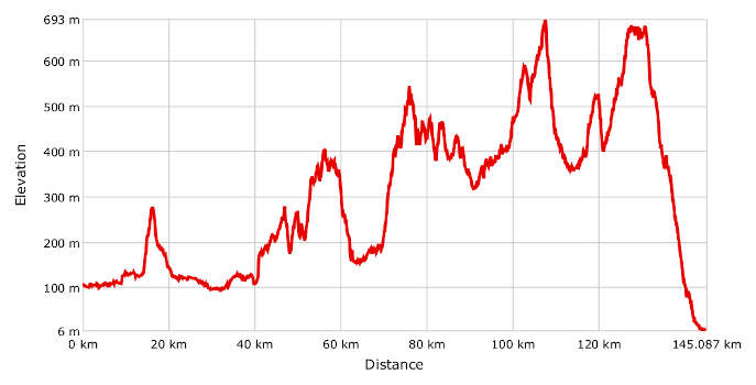
- Distance: 146 km
- Altitude difference: 687 m
- Total ascent: 2861 m
- Total descent: 2963 m
The idea of this route, conceived in 2008 by ASD Montalero Bike, was to create a metaphorical channel between the Ligurian Sea and the chequered sea of wet rice fields in Monferrato Casalese. The route has become a classic for mountain bike lovers over the years.
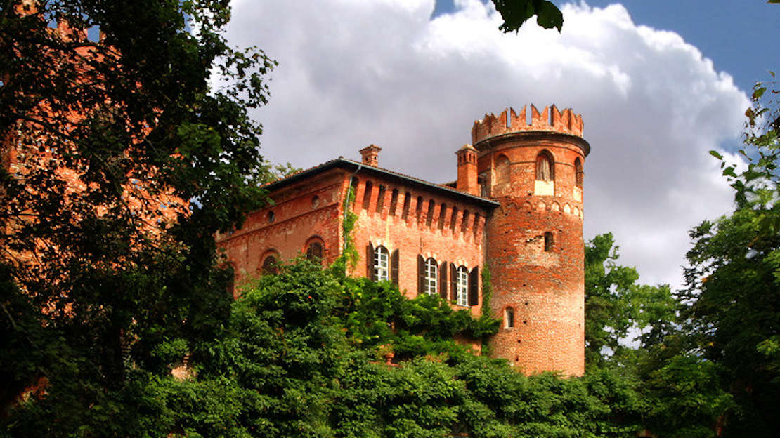
Every year, first ASD Montalero Bike, and after it disbanded, FIAB Monferrato Bike, have organised a two-day tour in June. It starts at Santa Maria del Tempio, a village near Casale Monferrato, and ends in Finale Ligure, after 146 km of tracks (around 80% of the route) and tarmac roads with little traffic (around 20%). The last stretch, to Finale Ligure, is a homage to the Ligurian city, whose Finale Outdoor association has created a series of MTB routes for tourists and cyclists from all over Northern Italy and neighbouring countries.
The itinerary starts in Santa Maria del Tempio (near Casale Monferrato) and passes by many places: Occimiano, Lu Monferrato, Quargnento, Felizzano, Redabue, Bergamasco, Castelletto Molina, Alice Belcolle, Castel Rocchero, Terzo, Arzello, Montechiaro d’Acqui, Case Scaiole, Squaneto, Località Brosi, Località Porri, Ferrania, Orco and finally Finale Ligure.
The trip is spectacular and incredibly scenic, but demands decent fitness and good bike control. If you plan your own trip, you can choose your own time frames and places to stop, based on your fitness. Quite a few of the tarmac roads are over hilltops and offer beautiful views. In Liguria, you'll cross the Adelasia nature reserve, on very uneven cart tracks and single tracks, so we suggest you use the GPX track.
Start in Santa Maria del Tempio, a village near Casale Monferrato, at the car park right in front of the church. Go through the last outposts of rice farming to Occimiano. From here, the climb to Lu Monferrato begins, before you go downhill to Quargnento and then through flat fields to Felizzano. Cross the river Tanaro and take the first track on your left, which will bring you to Redabue castle, then over some ups and downs through the hills to Bergamasco. Once you're out of this village, after the level crossing and the roundabout, go up the hill, which has a slope of 19%. Turn right at the top and after 3.5 km, you'll get into the woods of Mombaruzzo. Cross them to reach the cemetery at Fontanile. Take the downhill tarmac road in front of it then go up to Castelletto Molina.
Carry on towards Alice Belcolle, getting back onto the tarmac, and Castel Rocchero. Cross this village, following signs for Cascinone. Now you'll come to a steep descent, which brings you to Località Carrara Regione Costa. Go right to Terzo, a village near Acqui. Cross the river Bormida and go on in the direction of Melazzo, but change course after a few metres, turning left onto the track along the river Erro. Stay on it until you come to the tarmac near a bridge. Turn right here, then left at the junction for Arzello.
From Arzello, 68 km into the route, take a long uphill stretch to Montechiaro d’Acqui. It's worth stopping here to see the village, perched atop a hill. Turn back for about 1,500 m, until on your right you see a gravel road running sharply downhill to a single track, which leads in turn to the SP 220. Carry on to Località Brosi, where the tarmac runs out and turns into a track through the houses to Località Porri. You've now been in Liguria, in the hills of Dego, for more than 3 km. Go on through Pianelazzo Superiore, near Cairo Montenotte, over the highest point on the route, at 693 m.
Once you've passed it, go up to the Adelasia nature reserve. Once you're out of the woods, take a few tracks to Ferrania, where you'll see what's left of a building where photographic film used to be made.
Go left from it to a roundabout and on towards the centre of the town of Carcare. Go under the motorway and onto Via Nazionale, taking a left after a few metres. Follow the signs for Negreppie, go under another section of the motorway at the junction and back uphill, always following the main road. The tarmac runs out here and you come to the top of a high hill, clear of trees. Now it's time for a pretty downhill track ending at Località Acque. After Cartello Mallare, go right onto the track uphill to Le Tagliate. Go downhill for an exhilarating 15 km, passing by Orco and reaching the sea at Finale Ligure, by the river Sciusa, on Via Aurelia, Italy's great coastal road. Do not miss the chance for a dip in the sea at the beach.