- Bike: mtb
- Difficulty: **
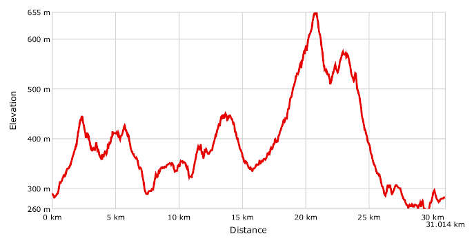
- Distance: 31 km
- Altitude difference: 395 m
- Total ascent: 947 m
- Total descent: 950 m
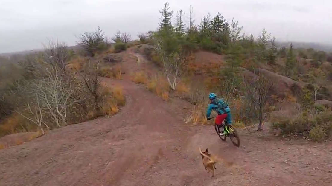
Rive Rosse is an area of the Alpine foothills between the provinces of Biella and Vercelli. Its many ghylls are often used as ramps between its red, sandy footpaths and tracks. The area provides particularly enjoyable cycling thanks to its semi-artificial jumps and ups and downs, the haunt of freeriders from all over Northern Italy and Switzerland. This route is mainly over dirt roads and singletracks through woodland, with some stretches on tarmac at fair gradients.
The peculiar character of the landscape that unwinds between the Strona di Mosso valley, Masserano and Curino is due to its geology. Part lies on granite, formed hundreds of millions of years ago at the Equator, in the subsoil of an African palaeocontinent, and later pushed towards what is now Europe. The other part is the fruit of the great lava flows that completely covered what is now a part of the eastern Biella area, after being submerged by ancient oceans and exhumed when the Alps rose, a little less than forty million years ago.
These very unusual types of rock produced the reddish-orange colour that makes the landscape so unique. It's not for nothing that a group of hills around the lake with its dam at Masserano are known as Rive Rosse, the 'red banks'. Consider also the heavy erosion on these rocks, many hundreds of thousands years old, and you can see why the country has such a surreal, almost alien appearance. Many of the hillsides have worn away into huge sand deposits; small wonder that there is even a church here dedicated to the Madonna del Sabbione, the Virgin of the sand bank.
ASD Racing Team Rive Rosse, based in Roasio, is an association local to the splendid Rive Rosse area, which organises not only sporting events but ones to promote tourism, the local area and its culture. One of its biggest competitive events is the Gran Fondo del Bramaterra at the end of every April. This is a 41 km race with a total climb of 1,350 m. The tour version is just 21 km long, with a climb of 600 m.
The 'Classic Rive Rosse MTB tour' presented here requires decent MTB skills and a minimum of fitness. The starting point is Brusnengo, in Piazza del Mercato, on the corner of Viale Carlo Verzone, a meeting place for all MTB lovers in Rive Rosse, where you can fill up your water bottles at the fountain before setting off.
Carry on along Via Eusebio Garizio, then Via Chiesa and Via Forte, where at the end of the street, you'll find the first paths to the little church of Madonna degli Angeli. From here, take a track and a fantastic singletrack through the firs to Rive Rosse, a very unusual area defined by its gravel humps of characteristic red. Here are your first tricky downhill stretches with some jumps too, which you could try out, with caution. Eventually the paths will bring you up to Villa del Bosco. More ups and downs bring you on to Lago Ravasanella, a reservoir 325 m above sea level, with a dam and picnic areas. Keep going up to the village of San Nicolao, which is followed by a beautiful descent. Go up to the hamlet of Curino, by the village of San Martino. Keep going up until you reach the village of San Bononio, then get onto the tarmac until you reach the highest point on the route, Monte Localà, 655 m above sea level. Here you will find a pretty picnic area and leave the tarmac for a tricky stretch on the up-and-down M41, the 'fishermen's path', which also slopes quite a bit, with the characteristic steps. Once you get to the 'peak of the rocks', you'll find a beautiful and exciting descent waiting for you. You should tackle it with the greatest care and attention, though. At the bottom of the hill, you'll arrive at Lago delle Piane, on a pretty stretch for picnics by the reservoir. Another singletrack will bring you to Parco Arcobaleno, where the Celtic festival of Beltane is held every year. Come onto little tarmac roads leading to the villages of Cacciano and Bozzone, then almost all the way to Masserano, another starting point for trips over the paths of the red country. You are on now the SP 233, the road back to your starting point in the town of Brusnengo, which you'll reach after about 1 km.