- Bike: strada/trekking
- Difficulty: ***
- Distance: 89 km
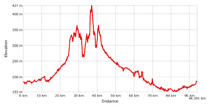
- Altitude difference: 274 m
- Total ascent: 787 m
- Total descent: 786 m
The Union of Baraggia and Bramaterra route covers two geographical areas that have formed a voluntary association to protect the hills and marginal plains, with a particular focus on the natural environment, effective use of human resources, safeguarding, restoring and promoting historical, cultural and religious traditions, reducing mass movement out of communities and defending the land.
The Unione tra Baraggia e Bramaterra (Union of Baraggia and Bramaterra) is a public body, with legal status, comprising the villages of Balocco, Buronzo, Carisio, Castelletto Cervo, Gifflenga and Villa del Bosco. The villages that have decided to participate in this association are geographically and culturally distinctive.
Gifflenga and Castelletto Cervo lie in the province of Biella, near what remains of the Piedmontese savannah, a unique geological, floral and faunal habitat which once extended over more than 40,000 hectares of heathland between the Biella foothills and the Vercelli area. Most of it has now become land for intensive rice farming, which characterises local agricultural production. Villa del Bosco, meanwhile, is the heart of a group of municipalities – Sostegno, Lozzolo, Roasio, Brusnengo and Masserano – dedicated to the fine wine that is Bramaterra DOC. This definition comes from the name of a local area, near the hamlet of Orbello.
Balocco, Buronzo and Carisio are in the province of Vercelli. Together with 28 other municipalities, these are part of the consortium for the protection of Riso di Baraggia Biellese e Vercellese PDO rice, extending over approximately 23,000 hectares of rice fields.
If you consider the rather unusual arrangement of the land in the Union, resulting from the combination of the two areas, you naturally see a dynamic combination. It is sharply contrasting in the variety of its environment and agriculture, yet also convergent, and truly stimulating at a gastronomic level, with its rice and wine!
Most of the route is on tarmac roads, with some stretches on tracks typical of rice fields or cart tracks through the foothills of the Biellese Alps. Smooth-rolling gravel, MTB or trekking bikes are recommended. Though most of the route is on the plain, therefore easy for everyone, it’s still quite challenging due to the climbs in the Biellese Alps. The highest point is 429 m a.s.l.
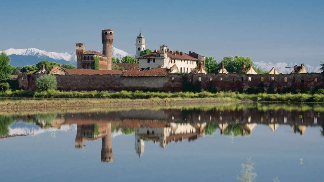
Start from Carisio, in front of the council building in Piazza della Libertà, which has a car park beside it. Take the village cycle paths on Via Buronzo to the SP 3, which passes through La Baraggia, Carisio’s industrial estate. When you get to the Fornace Crocicchio area, turn onto the track leading to Tenuta Masina then onto the SP 30 until Località Donna, where you turn right in the direction of Mottalciata. Just before the village, on the right is the hamlet of San Silvestro. A track leads to the little village of Gifflenga, where the premises of Unione tra Baraggia e Bramaterra are to be found at Cantone Chiesa 13. The church of San Martino, the village’s patron saint, deserves a visit. The route continues to Castellengo and its castle overlooking the hill. Keep cycling and pass the river Cervo to Cossato, the biggest centre in the area covered by the route. As you proceed, you start climbing, leaving the plain as the landscape becomes mountainous. You’re in Lessona, where the climb gets tougher on the road for Masserano until you reach it. Here, after a short drop, start climbing again on Monte Cicogna then until the Cima Granone, popularly known as Cima Coppi after the famous cyclist, at 429 m. This is the area of the Rive Rosse MTB enduro circuit (see the Rive Rosse MTB route in this guide). After some ups and downs, come to Villa del Bosco, a Bramaterra DOC village which is a member of the association that the route is based on. In addition to the centre, the parish church of San Lorenzo and numbered series of local centuries-old trees are worth a visit. Start coming down from the hamlet of Casa del Bosco in the village of Sostegno, leaving the high hills behind to drop into the expanse of the Po Valley and its baragge. Pass the hamlets of Orbello and San Fabiano in Loazzolo, among the many trails and tracks, and follow the GPX track to the village of Rovasenda and its attractive castle. The landscape changes completely, but the rural charm of the rice fields is a rewarding sight for cycle tourists.
On low-traffic provincial roads and tracks, come to Castelletto Cervo. Here, visits to the 10th-century Castello del Guado, the parish church of San Tommaso Becket and the nearby Cluniac monastery of Santi Pietro e Paolo are interesting. You can admire the canyons of the lower valley of the river Cervo. Follow the valley to Buronzo. The medieval ricetto, or fortified area, is of interest, as are the Augustinian friary and parish church of Sant'Abbondio. After leaving the village on the SP 6, you'll see a sign for Tenuta Isolazza' on your left. Go there and continue right up to the river Cervo. From here, go to another residential area. This is the village of Balocco, another member of the Union. Via Publica (now known in Italian as Via delle Gallie) is a Roman road passing through Balocco. Augustus had it built to connect the Po valley to Gaul. The local castle is of touristic interest, and was conquered by the marquesses of Monferrato with the lords of Rovasenda. Visiting the 11th-century parish church of San Michele is also important. Leave the village and pass Formigliana and Casanova Elvo with its historic castle residence. Leave the Cervo valley and come to that of its little tributary the Elvo. Head along the river then cross it to arrive at the historic hamlet of Vettignè in Santhià. A stop to visit the medieval castle here is a must. This is 5 km away from the starting point in Carisio, which you reach by tracks and provincial roads. Before finishing the route, it's worth your while visiting Garzaia di Carisio, part of the Lame del Sesia nature reserve.