- Bike: trekking/mtb
- Difficulty: ***
- Distance: 48 km
- Altitude difference: 188 m
- Total ascent: 1229 m
- Total descent: 1229 m
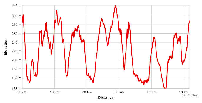
The UNESCO infernot trail us a 48 km circular route officially recognised by the regional government of Piedmont. We suggest riding a mountain bike or one that can go over tracks and dirt roads. The route goes up and down throughout, but the overall climb is not that great. The highest point is on Via Regione Bocca between Cella Monte and Treville, at 322 m above sea level.
The route winds through a landscape of hills mostly decked in vines. This area was declared a UNESCO World Heritage Site in 2014 for its vineyards, along with Monferrato Astigiano, Langhe and Roero. Monferrato Casalese is part six of the site, under the name 'Monferrato of the Infernot'.
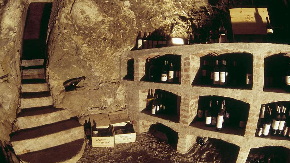
The infernot in question are a precious part of Monferrato's heritage. They are cellars, dug or carved into the sandstone under old houses, designed for storing wine in a dark place with natural air. In other words, they are treasure chests protecting valuable wine.
Only in a place like this, where wine is at the centre of culture, identity and centuries-old history, can you find magical microcosms created to store it.
Start in Piazza Mezzadra in Vignale Monferrato, then go up Via Roma to Piazza del Popolo and down Via Porro. Turn right when you reach the monument to sailors, then veer left onto a bumpy path that leads to the SP 50. You're now in Orti, where the route carries on past Fons Salera, an old thermal spa building. Take the road Regione Mongetto, which will bring you up to a dirt road to the town of Olivola. After an uphill slog you'll come to the little church of Santi Pietro e Paolo. The houses in this little village have been restored to display the calcarenite stone they're made of, which was dug from the nearby quarries. Follow the signs for Regione Costabella, where at the top of the hill you'll find a little red-brick church. Turn off for Ottiglio Monferrato. Once you get to the village, it's worth stopping at the Terra e Fuoco workshop, which is home to an infernot known as Maga Alcina. Get back on your bike and head on until you see the road sign for the CAI path number 746, 'La Valle dei Frati'. After the uphill push, turn right onto the dirt road to Cascina Monsaietto. A few metres on you'll find a rest area on your right. This is ideal for a picnic or quiet contemplation. Carry on along the road, which bends right and leads you back to the little red-brick church. Go on from here towards Moleto, a beautiful Monferrato village. Ride through the village then go down onto a stretch of the 'Valle dei Frati' path. Go up from this valley onto a track to the huge bench in Sala Monferrato, near the Baroque church of San Grato. Carry on in the direction of Cereseto, turning off before the village onto a steep uphill track for Treville. From this village, go up to Ozzano Monferrato for a visit to its infernot, then uphill again to the peak of the route, Regione Bocca. This road brings you to Cella Monte, home to the Ecomuseum of Calcarenite Stone. After a rest here, go down to Rosignano Monferrato, whose Palazzo Municipale has an infernot you can visit when the council offices are open. Go down into to the Ghenza valley, taking paths until you come to Strada Comunale San Bernardo, which leads to the village of Frassinello Monferrato. The route goes on to the hamlet of Castello di Lignano and a long downhill stretch to the junction with the SP 50. Stop and pay attention when you cross the road at the hamlet of Stramba before heading up to the village of Camagna Monferrato. After a little while, you can take a detour to Cascine Madonna before coming back up to the town of Camagna Monferrato, which has a few infernot in private houses. It's not far from here to the end of the route. Once you're out of the village, head for Vignale Monferrato. After about 1 km, go left off the tarmac road onto a path that takes you down to the vine-covered bottom of the valley, then back up to your starting point in Vignale Monferrato.