- Bike: trekking/mtb
- Difficulty: ***
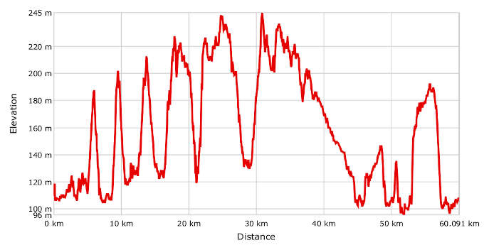
- Distance: 60 km
- Altitude difference: 149 m
- Total ascent: 1036 m
- Total descent: 1037 m
Rocchetta Tanaro was the first protected area in the Asti area, under Piedmontese regional law in 1980. The archaeological museum of Asti provides tours with park guides or authorised naturalists by appointment. There is also a path designed for blind people in the protected area.
The history of this place has been interwoven with that of a noble family, the marquesses of Incisa, since the 12th century. In fact, the idea of the park was put forward by Mario Incisa, marquess of Rocchetta, founder and for a long-time president of WWF in Italy. Most of the area is still owned by his descendants.
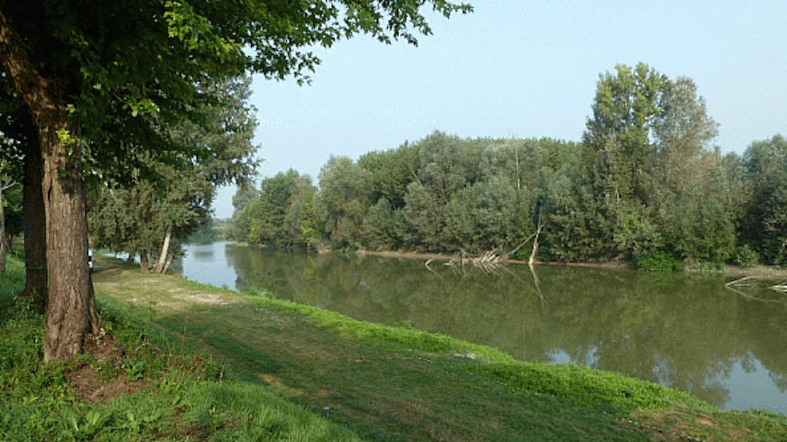
The protected area covers more than 120 hectares of woodland stretching from a hilly area down to the Tanaro. At the bottom of the valley, the boundary is marked by two state-owned streams, the Rabengo and Ronsinaggio, which receive the rainwater from the hills.
The park's great natural value lies in its woodland. Some is coppiced chestnut and black locust, some is a tall mix of sessile or English oak, pubescent oak, Turkey oak and, here and there, cherry, elm and maple. There are more than 100 grasses and flowers present, including the lady orchid, lily-of-the-valley, primrose and orange lily. The park's trees grow on slopes that emerged from the sea millions of years ago, forming the ideal woodland habitat for a range of animal species.
Man has left his mark in the forms of the little church of Sant'Emiliano, the tower of the old castle and the Romanesque 10th-century chapel, owned by the Benedictine abbey of Pomposa.
Start in Rocchetta Tanaro, in front of the council building in Piazza Italia. From the square, you can cycle round the outer walls of the castle of the Incisa family, the marquesses of Rocchetta, with its medieval charms. Begin the trip by pedalling off in the direction of Asti. On the first road on your left you will see the signs for Sant’Emiliano and Gatti. Keep right until a bend where you will see a track on your right, with a sign for Rocca d’Arazzo. You will reach this village by a road running along the river Tanaro. After perhaps stopping for a rest, carry on along Via XX Settembre until you reach the SP 15, where you must turn right. Go on and, when you reach the curve, follow the sign on your right for the retirement home M. Cirincione. Turn right and carry on along the track, leaving the home on your left. Go on along the banks of the Tanaro for another 1,400 m. After this, the hilly part of the route begins, to Azzano d’Asti. At the top, you can enjoy a beautiful view of the Tanaro river plain and the city of Asti. Go from Piazza del Peso up to a road that quickly becomes a track. Keep right at the first junction and then left to arrive at the bottom of the valley, where you enter Via Montemarzo. Carry on to the hamlet of Santa Caterina di Rocca d’Arazzo. Turn left on the SP 39 and on to the sharp downhill bend to the right, followed by a series of pretty ups and downs on a dirt road to the Rocchetta Tanaro natural park. Among the wonders of the ancient woodland here you will find a maze of footpaths, although given that you still have a long way to go, we recommend you stay on the main trail. You will also find an information point set up by the park authority, near to which a hostel nestles among the greenery. Once you get out of the park, go to Belveglio, over the river Tiglione and up through the dense woods of the Val Sarmassa natural park to Cortiglione. After a quick stop-off, take the long path through the greenery towards Oviglio until you reach the foot of the hill on which the 13th-century castle of Redabue sits, surrounded by a park. To visit the building, you need to check the opening times in advance. The end of the route is just 14 km away but it's worth stopping in Masio. The village's unmistakeable symbol is its 13th-century medieval tower, which has been declared a national landmark. It has a museum that you can visit, with an exhibit, 'The tower and the river', that takes you on a fascinating journey up the tower and through the history of the building and the local area. Get back in the saddle for the last stretch of the path, from the Tanaro to the hills, which is trail no. 870 in the province of Alessandria's hiking network. Go down and cycle alongside the river again for about 600 m. This is the most ancient part of the trail, and was part of Via Fulvia in the Roman era. Go back up along the numbered path through the woods and little clearings, offering glimpses of the Tanaro and the land around. You will arrive near the Cantina Sociale (wine cooperative) in the hamlet of Mogliotti, where you go down and along the river for the last time until Rocchetta Tanaro.