- Bike: mtb
- Difficulty: ***
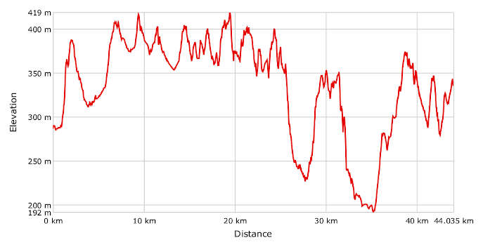
- Distance: 44 km
- Altitude difference: 227 m
- Total ascent: 1072 m
- Total descent: 1018 m
The Great Path of the Rocche of Roero crosses the whole ridge through the eight villages that have perched on the crags for a thousand years. The path winds for 44 km between Bra and Cisterna d'Asti, giving you excellent views of the varied landscape in the Roero area and the lush nature that distinguishes it. The Great Path of the Rocche of Roero, also known as the S1, is an amalgam of various themed routes. The S1 path is marked by posts and can be cycled in either direction.
Montà d’Alba is home to the Ecomuseum of the Rocche of Roero, which looks after and promotes the maze of paths in Roero and around the Rocche. It also suggests guided nature tours for visitors and rented audio guides with plenty of audio and photo content that act as GPS navigators as well.
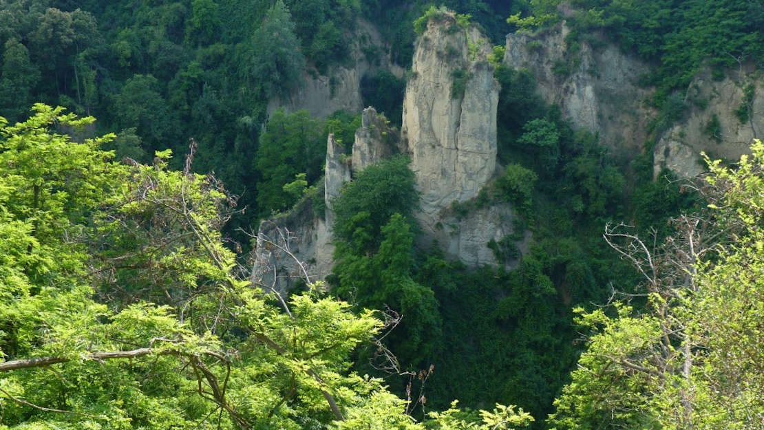
The Rocche ecosystem is very delicate. Different micro-climates coexist here, a few hundred metres above sea level. The pine and pubescent oak, typical of dry habitats, grow here on the ridges, while at the bottom of the gorges it is humid.
The S1 path begins in Bra, where the international Slow Food movement began. The town is also home to Baroque churches and archaeological, natural history and toy museums.
At the shrine of the Madonna dei Fiori, you'll find the first signposts on the S1 path, which takes you out of the town centre and into the thick woods of America dei Boschi and Saliceto hamlets near the town of Pocapaglia. From here you reach Pocapaglia, the first hilltop village on the route, with a spectacular view of the Rocche and a castle that dominates the surrounding area.
The journey goes on past rocks, oak and chestnut woods to Sommariva Perno, known for its castle, once home to La Bela Rosin, wife of King Vittorio Emanuele II. Their marriage was considered 'morganatic', as she was a commoner. The route through the village takes you past all the places where she left her mark.
Once you've left the village, carry on to Baldissero d'Alba, a long, faithful historical enclave of the marquesses of Saluzzo in the land of Asti. Cross one of the highest ridges of the Rocche and you'll come to what was known in ancient times as the silva popularis, the primeval forest that once covered the whole plain between the river Tanaro and modern-day Turin. This is one of the most wooded and beautiful parts of the route. It brings you to a flat area dotted with chestnut trees.
From here you'll come to Montaldo Roero, the smallest and least populated of the villages on the ridge. The landscape is defined by orchards and vineyards with a beautiful medieval round tower poking out of them.
The S1 path then approaches Monteu Roero, winding its way through chestnut groves and rocky ridges. Once you get to the cemetery, a little deviation off the S1 path will bring you to the historic centre of the village, with its mighty castle, a perfectly preserved medieval fortress. The history of Monteu Roero is intertwined with that of two families who ruled it over the years: the Biandrates, who took it in 1153, and the Roeros, powerful Asti bankers who held feudal estates all over Roero and gave the area its name.
From the main square in Monteu Roero, take the S1 path along the provincial road for Turin, taking in the beautiful landscape of the Rocche on your left and right. The path turns right towards the village of San Grato and snakes its way through the surrounding farmland. Once you've passed the farm Cascina Prella, you'll come to a valley of chestnut trees. The climb to Località Carretta, near the village of Santo Stefano Roero, takes a short bit of effort.
The main square in the village sits on a lovely promontory that once hosted a medieval tower and is now the site of the imposing parish church of Santa Maria del Podio, the tower having collapsed into the valley below due to the sandy ground it stood on. The centre of the village is entirely pedestrianised.
Take a sharp turn uphill to Bric Bissoca, where you'll find the old aqueduct with its splendid view of Monviso mountain. From here you'll get to the heart of the Rocche ‒ where marine fossils peak out ‒ and the shrine of the Piloni, a little sacred mount among Scots pines and vineyards. This has been a pilgrimage site for centuries and even earlier, in pre-Roman times, was dedicated to the cult of the goddess Diana, who lends her name to the valley below. Visit the church of Santi Giacomo Minore e Filippo, which has a Roman plan and fifteen chapels with a great Way of the Cross, a parade of statues acting out the Passion of Christ. The religious section of the route ends at a lonely hillock on which sits the large chapel of Santo Sepolcro. Legend has it that it was built as a votive chapel by Crusaders returning from Jerusalem.
The S1 path carries on downhill, following the dry course of the Canneto stream and coming out into the Diana Valley, full of plants typical of humid areas. Head back uphill towards the ridge village of Montà, home to the Ecomuseum of the Rocche of Roero. Pass the old parish church and the 17th-century castle of Morra Lavriano, a real jewel shrouded in peace and silence.
After the chapel of San Grato, you'll pass Valle delle Rocche, a mountain bike training area. If open, it's worth visiting. Go right from here onto a road of very fine sand, running through vineyards and beautiful chestnut groves. When peach orchards start popping up among the vineyards, you know you're near the town of Canale, which holds a festival every year in honour of this fruit with a wide range of events and activities. Go up a road overlooking Madonna di Loreto on the right. This village is defined by its little country church, inside which you'll find a 15th-century fresco of the Virgin and Child.
Once you've passed Casa Naura, a house with a canopy used for events in summer, the S1 path takes you for a long stretch on Via Lunga, a wide, flat road through chestnut coppices and woods of black locust. You can take a detour here to the shrine of San Nicolao, a holy spot in the heart of the Rocche around Canale, but the S1 path carries on through the woods to its end in Cisterna d'Asti, the gateway to Monferrato Astigiano and the final stop on our route. Finish off with a visit to the Museo degli Antichi Mestieri (museum of the old masters) in the imposing medieval castle and perhaps a sample of the local cuisine.