- Bike: trekking/mtb
- Difficulty: ***
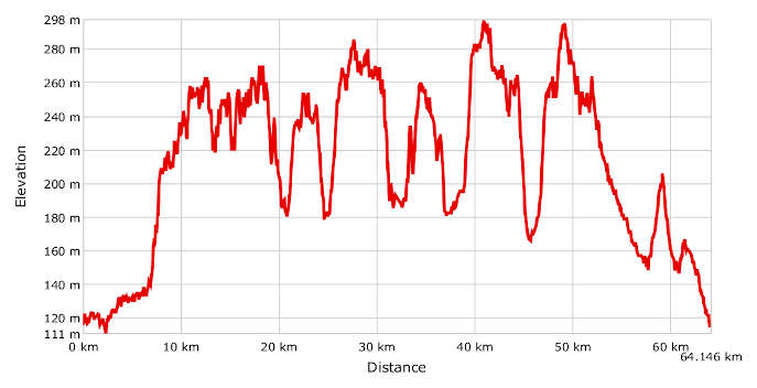
- Distance: 64 km
- Altitude difference: 187 m
- Total ascent: 1061 m
- Total descent: 1063 m
Romanesque churches represent a part of the Province of Asti’s great historical, artistic and cultural heritage, a treasure preserved over the centuries and the object of conservation and promotional activity in recent years. These invaluable little gems bear witness to the Middle Ages and are mostly to be found in the north of the province, in Basso Monferrato between the Po and the Tanaro. The Via Francigena ran through this area in that period and European pilgrims took this path to reach Rome and the Holy Land.
Well into Monferrato’s history, castles were constructed for defensive purposes and new settlements were developed for strategic reasons. As time passed, those little villages were abandoned and the pieve churches transformed into cemetery chapels or country churches.
Begin the route in Asti in Piazza Campo del Palio. If you would like to visit the city, refer to the urban route in this guide to find information on Asti’s principal monuments.
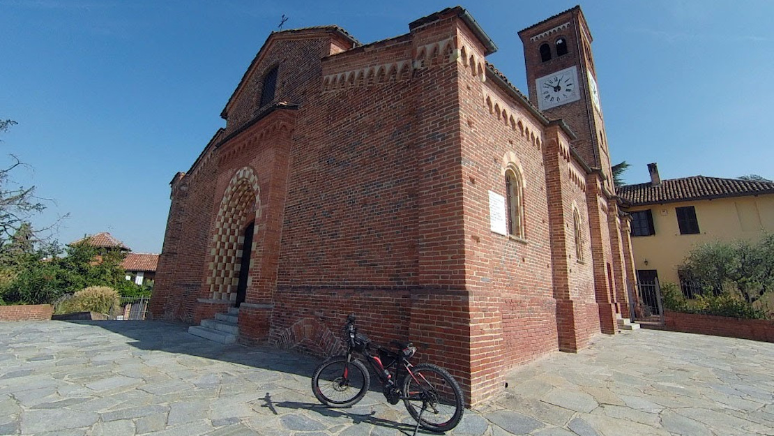
Exit the city to the north in the direction of Viatosto via the cycle paths near the river Borbore. Head towards Sessant and continue via the hamlet of San Grato, where a pleasant dirt road amid woodland leading to Settime will soon begin. After coming to the village, continue to its cemetery where you’ll find the Romanesque church of San Nicolao at the bottom of a road lined with cypresses. The back of its apse features a succession of Lombard bands and half columns and capitals with vegetable ornamentation and anthropomorphic motifs.
Head back in the direction of Cinaglio where the little 12th-century church of San Felice can be found in front of the cemetery. Its Romanesque features can be observed above all in the outer wall of the apse, while there are still frescoes dating back to the end of the 15th century inside. Having crossed the village, get back on the SP 35 at the church of Sant’Antonio Abate and continue as far as the chapel of San Rocco. Keep left then turn right onto a lovely little road running through woodland, then left after the church of San Grato to reach the hamlet of Vanara. Keep right at the chapel of Santa Lucia and continue, following the GPX track, to Montafia where you’ll find the charming church of San Martino. The original construction probably dates to the mid-12th century. The diocesan register of 1345 contains the first traces of the existence of the church of San Martino in Montafia, now beside the cemetery.
Continue towards the village of Montafia without entering it. Then, when you reach the crossroads, turn left then right on the SP 10. Keep on until you turn right onto a track and, after a few metres, take the track on the left that leads to the church of San Giorgio in Bagnasco. It dates to 1153. It was the historic parish church and is now in the cemetery. This building seems imposing when compared to most of the other Romanesque churches in the Asti area. It has a three-nave layout and a sober interior, roofed with visible trusses and tiles. A 17th-century San Giorgio is preserved on the vault of the central apse. Continue on the track, following the little roads and trails until you arrive at the charming church of San Secondo. This rises from the enchanting location of Mongiglietto, about 1 km west of the residential area of Cortazzone. Considered one of the Asti area’s most interesting Romanesque structures, it dates to the beginning of the 14th century. Its imaginative decorations are remarkable, as are the sculptures adorning the southern wall, apses and interior capitals. The church is still open for worship, with the feast of San Secondo – patron saint of both Asti and Cortazzone – celebrated here.
Get back on your bike to continue to the village of Camerano Casasco and its picturesque castle, then on roads and trails to Chiusano d’Asti for the church of Santa Maria. This dates to the 12th century and was partially restored in 2002, but is now in a state of neglect. Continue through the Cossombrato village area to the Shrine of the Madonna dell’Olmetto then enter Valmanera to come up to Asti at the Church of Santa Maria di Viatosto. Viatosto was likely to have been a little village clustered around a pieve church with cemetery. The first concrete information dates to the 11th century and identifies the church with the name of Santa Maria de Riparupta (Rivarotta). The origin of the place name ‘Viatosto’ is uncertain. In historian S G Incisa’s 1806 text Asti nelle sue chiese ed iscrizioni, he conjectured that it comes from the miraculous end of the plague in 1340 in Asti, which – ‘via tosto!’ or ‘ayatost!’ (away quickly) – was rapidly liberated in its entirety starting from that location. The building stands on a hill that enjoys a wonderful view and blends Romanesque and Gothic architectural elements masterfully. This area represents the last stop on the route, which continues down towards Asti to return to the point of departure.