- Bike: strada/trekking
- Difficulty: *****
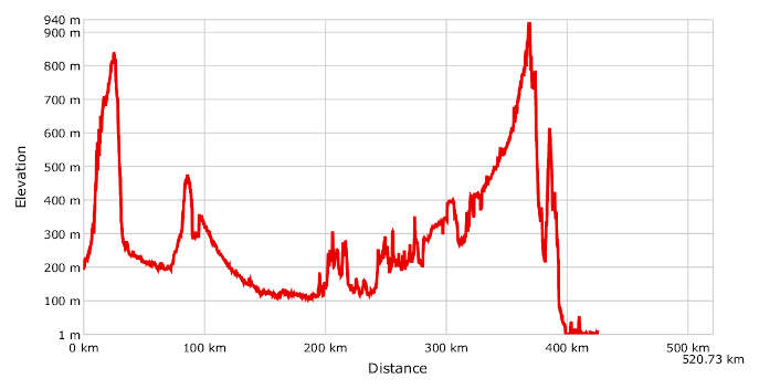
- Distance: 520 km
- Altitude difference: 939 m
- Total ascent: 6669 m
- Total descent: 6854 m
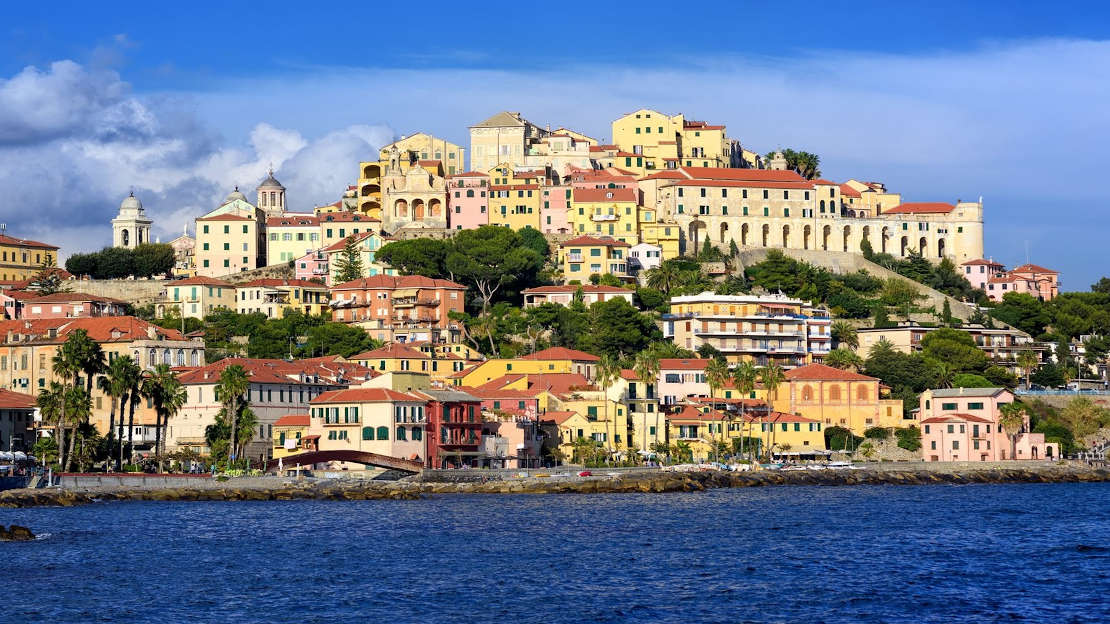
The Switzerland-to-the-sea cycle route is marked by Bicitalia, the Italian cycle route network (www.bicitalia.it). It starts in Locarno, a city on Lake Maggiore in the Ticino canton of Switzerland, and ends about 520 km later in San Remo, the 'city of flowers' on the Ligurian Sea.
The cycle route crosses six Piedmont provinces, stretching from the basin of the Verbano-Cusio-Ossola lakes to the Novara plain and the Vercelli rice fields. Riders also pass through the rolling Monferrato, Alessandria and Asti hills, the Tanaro river basin that skirts Roero and Langhe, and the upper Tanaro valley in Colle di Nava before going down to Imperia.
The stretch in Liguria follows along the ridges and terraced olive groves in Imperia's hinterland then leads to the coast where cyclists pedal in the converted area of the former railway tracks, now called the Riviera dei Fiori coastal park cycle route, which flanks the beaches and cliffs until it reaches the palm trees and gardens in San Remo.
The route runs along the terraced olive groves in Liguria then descends to take the cyclist through seaside villages to the beaches and cliffs. The cycle route is one of the most prestigious north-south tracks. It uses the Swiss national route no. 3 in the Ticino Canton to connect the Central European EuroVelo 7 route to the EuroVelo 8 route going west towards Provence and the Mediterranean towns.
On the north-south Switzerland-to-the-sea route, which takes cyclists from the Ticino canton in Switzerland to the Riviera dei Fiori, there is a series of surprisingly lovely landscapes and historic cities:
the lush gardens of Verbano-Cusio-Ossola, the endless sea of mirrored squares in the rice fields of Novara and Vercelli, the shifting profiles of the hills, villages and castles of Monferrato and Langhe, and the bustling cities of Novara, Vercelli, Casale Monferrato, Asti and Alba, which are at the core of historic and cultural Piedmont. Not to mention the bends and curves of the river Tanaro, where the railway that has not been used for more than 11 years is still waiting to be revitalised and transformed into a cycle path. Other landscapes not to be missed are the woods of Alta Valle and the lavender and broom fields emitting their unmistakable scent in Colle di Nava at the edge of the region.
The route can be split into different geographic areas and travelled in convenient legs.
Leg one: crossing the mountains to the lakes (125 km approximately). This leg goes from Locarno, on the north side of Lake Maggiore in Switzerland, passing through Vigezzo valley, the painters' valley, to Domodossola. Continue to the Ossola valley, following the river Toce to Gravellona Toce, then Omegna and Pella on Lake Orta, until you reach Gozzano. From here, continue along the Novara valley to Borgomanero.
Leg two: Vineyards and Rice Fields (93 km approximately). A Piedmont saying reads: 'Rice is born in water and dies in wine.' This saying goes back to the Piedmont dish panissa, a risotto with beans and salami, doused in fine wine. To celebrate this food and wine combination, the leg starts from Borgomanero, capital of the Novara valleys, where premium wines like Ghemme and Gattinara are produced. When you reach Novara, continue on to Vercelli and Casale Monferrato by means of the Po valley and the long stretches of Piedmont rice fields.
Leg three: From Monferrato to Roero Aleramico” (108 km approximately). This leg starts from Casale Monferrato, the ancient capital of Monferrato, and ends up in Bra, the historic capital of Roero where some of the land remained property of the Aleramici family until the 18th century. This leg passes through the following towns in the Casale Monferrato area: Terruggia, Conzano, Camagna Monferrato and Vignale Monferrato. It also goes by towns in the Monferrato Asti area: Casorzo, Grana, San Desiderio di Calliano, Portacomaro and Asti. From Asti, the capital of the province, take off again towards Antignano and San Martino Alfieri. Govone is the first town in the Roero area. It is followed by Priocca, Castellinaldo d’Alba, Vezzo d’Alba, Piobesi d’Alba, Monticello d’Alba, Macellai di Pocapaglia and Bra. Here you should visit the city's symbol on top of Monte Guglielmo: Villa di Delizie, also known as Zizzola, a noble residence.
Leg four: Langhe and Colle di Nava (109 km approximately). The elevation is significant on this leg since you go up to the peak of Colle di Nava, the pass in the Ligurian Alps 934 m above sea level. The overall climb on this leg is 1,467 m and you start in Roero at Bra then continue through the Tanaro Valley to Carrù and Ceva. The leg continues at a maximum gradient of 13% through the upper Tanaro valley, passing Bagnasco, Garessio and Ormea until reaching the Nava Plains. At this point you are in Liguria, in the province of Imperia.
Leg five: from the mountains to the sea (85 km approximately). From the pass in the Nava plains, also called the lavender hills', you start your descent. Go down for about 25 km then sprint for about 300 m and finally head straight down to the sea for another 20 km or so until you reach Oneglia and Imperia. You'll need to go a few kilometres on the urban cycle paths and Via Aurelia, but once you reach San Lorenzo al Mare you will travel on the long Cycle Route in the protected Riviera dei Fiori coastal park. After about 24 glorious kilometres that take you through tunnels and special rest areas for cyclists, you will get to San Remo, the 'city of flowers', home to the famous Sanremo Music Festival. Your final destination is the town railway station.