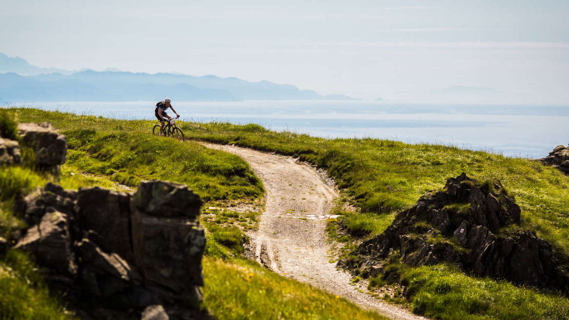
- Bike: mtb
- Difficulty: *****
- Distance: 400 km
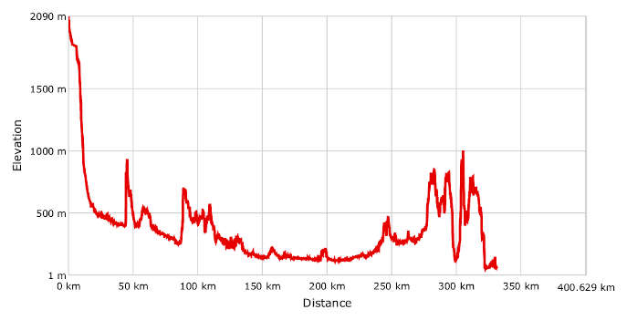
- Altitude difference: 2089 m
- Total ascent: 8246 m
- Total descent: 10331 m
A mountain bike route that begins in the Alps by Lac du Mont-Cenis, runs through the Susa valley to Turin, crosses Monferrato to Alessandria, comes back into Monferrato at Tortona, crosses the hills of Gavi, climbs the Piedmontese and Ligurian Apennines and finally reaches the sea at Sestri Levante, from where the ancient Via Francigena carried on along the sea to the Vatican in the eternal city of Rome.
Since the Middle Ages Via Francigena has been an important route for communication and pilgrimage, the site of cultural and commercial exchange between people with different values and traditions.
Piedmont was especially important as the point of passage between the Alps and the Po valley. Even after the Roman era, Turin, or Augusta Taurinorum, as it was known, was already a strategic connecting point for direct routes to the most important passes in the Alps, as well as Rome and the Holy Land. Travellers used the consular road to Vercelli and Piacenza and the Roman roads like Via Fulvia, which led to the sea through the hills of Monferrato, Asti and Alessandria and along which you will still find many religious buildings, including abbeys.
The route stops at important holy places and UNESCO heritage sites. In the Susa valley you will find the Sacra di San Michele, an imposing Romanesque religious complex founded around the year 1000 AD, and a symbol of the region of Piedmont since 1994. In Turin you have the basilica of Superga, also called the ‘Real’ basilica, built in 1731 by king Vittorio Amedeo II to thank the Virgin Mary after he defeated the French. In Albugnano is the canon house of Santa Maria di Vezzolano, a Romanesque-Gothic religious building that is one of the most important medieval monuments in Monferrato in Piedmont. In Morialdo, a village near Castelnuovo Don Bosco, you will find the basilica of Don Bosco, a recent building from 1961 on the site of the birthplace of St John Bosco. It is also a site of great pilgrimages, with many witnessing the presence of the saint himself.
Romanesque churches are part of the province of Asti's heritage and attractions of great artistic, historic and landscape value. They bear valuable witness to the Middle Ages and are particularly concentrated in Basso Monferrato, where they perch on lonely hills between the rivers Po and Tanaro.
At the same time, every corner of the province of Alessandria bears the traces of the slow yet never-ending passage of people. Merchants and pilgrims left marks of great religious traditions and evocative places where you will not struggle to find little jewels, like Romanesque and little parish churches and manifestations of popular culture.
The description of this long route will be limited to the places it passes through and its climbs and distances, in order that you, the pilgrim cyclist, can plan your journey better.
Start by Lac du Mont-Cenis, an artificial lake by the pass of Mont Cenis and the town of Moncenisio, at an altitude of 1,974 m. From here you begin the long 25 km descent to Susa (503 m). From the capital of the Susa valley, you go down to Bussoleno and Chiusa di San Michele (378 m). Take the path uphill to Sacra di San Michele (960 m). Carry on to the lakes of Avigliana and the town of the same name (382 m). From Avigliana take the Via dei Pellegrini to Rivoli, then the road to Pianezza, Collegno and Turin. Leave the regional capital and take the cycle paths to Sassi (210 m), from where sentiero 28 and sentiero 29 will take you to the hill on which the basilica of Superga sits (672 m). By now, you are 100 km into the route. Go down the paths to the hills of Turin, Bardassano, Sciolze and Cinzano, then into Monferrato and the canon house of Santa Maria di Vezzolano, near in Albugnano. It's not far from here to Castelnuovo Don Bosco, and about 5 km from there to the Basilica di Don Bosco, in the village of Morialdo. Pass through Capriglio, home to the museum of Mamma Margherita, St John Bosco's mother, and on to Montafia, Cortazzone, Cinaglio, Settime and finally the city of Asti. Crossing the Tanaro valley pass through the towns of Castel d’Annone, Masio and Oviglio, 200 km into the route, then Villa del Foro and finally Alessandria, known as the city of bicycles. Cross the river Tanaro to Pietra Marazzi, Rivarone, Sale, Castelnuovo Scrivia, Pontecurone, Viguzzolo and Tortona. In the Roman era, Tortona, then known as Dertona, became important thanks to its strategic position, already known to the Ligures and strengthened by the great consular roads Via Postumia (Genoa–Piacenza–Aquileia), Via Fulvia (Pollenzo–Asti–Tortona) and Via Aemilia Scauri (Vado Ligure–Acqui–Tortona). These interlinked, making the city a commercial and military crossroads important throughout Northern Italy. From here the route to the sea along Via Francigena runs south through the hills of Tortona. Today, in homage to the 'Champion of Champions', Fausto Coppi, the route goes through Castellania before heading down into the Scrivia valley and Arquata Scrivia, 300 km into the trip. From here you go back up into the hills of Monferrato until Gavi, the ancient fortified town that was a stopping place for pilgrims before they tackled the Apennines. Carry on to Carrosio, Voltaggio and Fraconalto, where the climb to the Apennines begins. Go through the Passo dei Giovi (472 m) and onto the track Alta Via dei Monti Liguri until Struppa, a district of Genova lying in the Bisagno valley, a little more than 100 m above sea level. From here you go up again, to the top of the mountains of Traso, where you will find the electric beacon for planes at Bargagli. Cross the villages of Pannesi di Lumarzo and Uscio, then about 20 km downhill to the sea at Chiavari, then Lavagna and finally Sestri Levante. You reach Sigeric's route along Via Francigena at Sarzana, after around 67 km. From here the journey to Rome takes you away from the sea, but is extremely scenic and historic.