- Bike: mtb
- Difficulty: ****
- Distance: 68 km
- Altitude difference: 604 m
- Total ascent: 1798 m
- Total descent: 1751 m
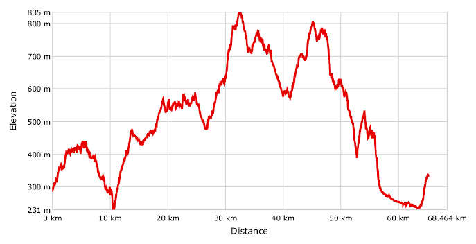
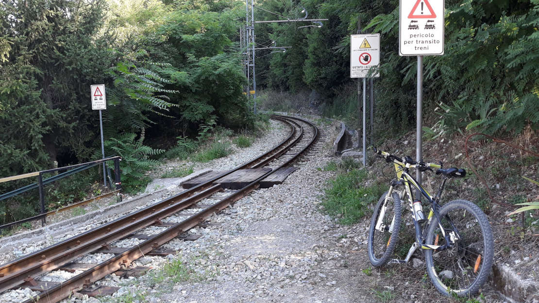
Start in the centre of Genoa on Largo Zecca, 2 km from the Genova Principe railway station. Load your bike on board and take the Zecca–Righi funicular railway up to the Park of the City Walls. Get off at Righi, the last stop, and carry on mostly uphill along Via Mura delle Chiappe, Via Costanzi, Via Asmara and Via del Peralto, and enter the park. The view from here of the city, port, forts and city walls is beautiful. Once you reach the helicopter landing spot, take the small road on your right through a gap in the walls and go down and then up, keeping the walls on your left. Sperone Fort towers above you on your left. Continue on the small road, which goes up before flattening out. Go up again on your left to the Osteria delle Baracche, then straight on the gravel road for about 4 km on mostly flat surfaces. You will travel along the rim of the park and enjoy wide views of the Puin and Diamante forts on your left and the Bisagno Valley on your right. The road ends at the Trensasco Pass, near the restaurant La Baita del Diamante. Cross the provincial road and carry straight on along the tarmac road. This will take you right into the woods and downhill to Crociera di Pino, near a stop on the Genoa–Casella railway line. Cross the platforms and go down the path for a little while to a brick path that leads down to Via Costa di Pino then along the SP 43 on your right for 500 m. Take another right onto Via San Bernardo and you'll soon reach the little church of the same name. From the church, take Via del Sale, which quickly becomes a gravel road and then a single track through the woods. Pay a bit of attention here because some stretches of the path can be a little dangerous. After just 600 m you can start going full speed again. The path descends significantly before coming out onto the tarmac at the hamlet of Vallombrosa, near the chapel of the Grazie. From here, turn right and go up Via Vallombrosa. The road ends near the railway platforms on the Genoa–Casella line. Cross the platforms and carry on along the lane among the houses. Go past a few steps and back onto the tarmac up to Via Cà Rasori. The road leads to Via al Consiglio and up into the countryside scattered with houses, orchards, vegetable patches and unfarmed fields. Keep going up, including round some bends, to arrive at the top of the hill. Go down sharply to the SP 2 near Busalletta railway station on the Genoa–Casella line. Go right on the SP 2 until you arrive in Crocetta d'Orero, the watershed between the Po and the Tyrrhenian rivers on Alta Via dei Monti Liguri. From Crocetta d'Orero, go up to the left on the tarmac road that leads to Orero and Costa Fontana. From the little church in this last village, go right and take the small tarmac road on the south-western slopes of Monte Capanna for about 800 m of ups and downs. When the small road bends sharply to the left, go off it onto the track. The track keeps running parallel to the ridge. Once you've got past the Castello farm stay, you'll be back on the tarmac. Turn right sharply to go uphill to the first tarmac junction. Once you get to the top of the hill, the tarmac road ends. Take the track downhill on your left and go through the woods to the SP 47, near the shrine of the Vittoria. Go left on the SP 47 and you'll soon arrive down at Giovi Pass, another historic pass in the watershed between the Po and the Tyrrhenian rivers. From the pass, go west onto Alta Via dei Monti Liguri, which is an uphill tarmac road for about 600 m, then a track for 2 km. It takes you into Piedmont and onto the Pian di Reste plain. Here you'll see signs for the oil pipeline. Take a sharp right uphill and follow the Piedmont hiking network signs to Fraconalto. The track will soon bring you to the slopes of Monte Poggio, the highest point on the route at 835 m above sea level. Here a long stretch of ups and downs begins, mostly along the ridges that separate the Scrivia and Lemme valleys. At the points where it is possible to cycle, this stretch follows the European E1 path. The first part of the stretch is still on a track and takes you to Fraconalto, where you'll come back out on the tarmac. Leave this little village downhill on your right and you'll arrive at the Castagnola Pass. Once you've crossed the provincial road, carry on up on the tarmac to Porale. The road now goes up through the beautiful rocky countryside of Monte Alpe di Porale. Once you reach Porale, turn left sharply and keep going up on the tarmac. You'll come to a little chapel with a monument to the Alpini soldiers. Take the track on your left. The track goes up to the ridge and around the peak of Monte Brignone. Go straight on rather than taking the track down on your left along the E1 path. The single track on the right is better for bikes. This path winds for a while around Monte Pagliaro before going back down onto the E1 path. From here it's not far to Borlasca on the track. Take a right onto the tarmac road and follow it for a short while to the village, leaving it here almost straight away and going up on your left onto a track. Although this first part of the stretch follows the E1 path, you'll now leave it after about 1.5 km and turn left, taking a track to Sottovalle. Here you'll come back out onto the tarmac and follow it left downhill through the village. Pass the cemetery and after about 100 m, turn right onto the track that goes up to the hills. Go up to Masseria Cappelletta. The track becomes an old mule road then meets up again with the E1 path, which goes down into Arquata Scrivia, but you need to go in the opposite direction, returning into the woods and quickly arriving in Pratolungo Superiore, a hamlet of Gavi. The tarmac returns as you go down to the beautiful valley, where you'll see the first vineyards on the route. You are now in Monferrato. The small road crosses the busy SP 161, which links Serravalle Scrivia with Gavi. Stay left on the small road to go through the fields keeping Gavi's Genoese fortress in the background. Once you get to the cemetery, turn right onto the SP 161 and leave it after a few dozen metres, going up about 1 km to the fortress.