- Bike: strada/trekking
- Difficulty: ***
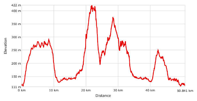
- Distance: 51 km
- Altitude difference: 311 m
- Total ascent: 983 m
- Total descent: 982 m

Start from Casale Monferrato, on Viale Lungo Po Gramsci in front of Monferrato Castle. There’s a big car park here. The administrative office of the Po natural park is a matter of metres away. This park has always led in promoting nature and educational tourism in the protected area of the river and floodplain. You can get dedicated information on the historical, naturalistic and agricultural aspects of the most characteristic areas of the Po in Vercelli and Alessandria here.
Set off in the direction of Via Rita Levi Montalcini, then follow Via Salita Sant’Anna. From the top you can savour a panoramic view of the town. Further on, the viewpoint looks towards the village of San Giorgio and its medieval castle. Carry on along Strada Baldovina as far as the little chapel and turn right, continuing to the first track on the left, in the direction of Cinaglio, Laurenta and Moncia. After Moncia, which you can recognise by the dome of a former observatory, come down to the hamlet of Rollini. Come onto a nice descending track, passing in front of a private runway. Turn right at the junction and come to the hamlet of Cascine Lunghe. Continue on tarmac here to the crossroads leading to Pontestura. Turn left onto the SS 455, then right and right again after about 400 m between the houses. The track crosses the fields up to Castagnone di Pontestura.
From this village, head towards Madonnina, one near Serralunga di Crea. You can top up with water here in the square near the church of La Madonna del Cappello. Head from the square towards Strada Vignassa and turn left at the stop sign towards the hamlet of San Iorio. On the bend, come onto the track. Turn left at the Serralunga di Crea cemetery onto the SP 19. Here you need to follow signs for the 'santuario' (shrine), quickly passing the village of Forneglio.
The climb has a total length of 2,500 m and average slope of 9%, with 13–15% sections at the chapel of the Martirio di Sant’Eusebio, Cascina Cappelletta and the Tenuta Tenaglia farm. It starts at a height of 165 m (in Madonnina), reaching a height of 422 m in the square of the shrine.
The 47 hectares of the Sacro Monte di Crea natural park have an altitude ranging from 355 to 455 m above sea level. The protected area has toilets, picnic areas and an information point with material on climbing the Sacro Monte.
After the climb, if you need information on visiting the site and the scheduled events organised on the Sacro Monte, you can head for the office Ente di Gestione dei Sacri Monti before heading up to the shrine. It’s in Cascina Valperone (heading towards Ponzano, on the right about 400 m from the Sacro Monte and the shrine. Their staff can provide helpful information during office hours and the centre has a multi-purpose room and extensive library, since it houses the documentation centre for all the sacri monti.
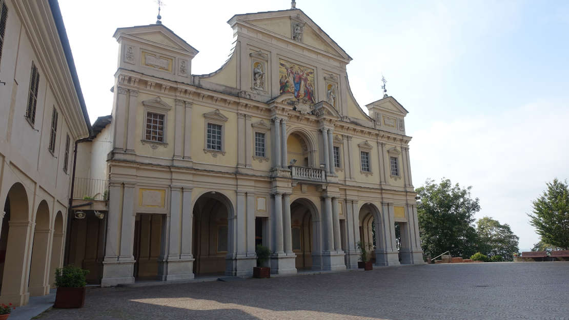
There is a devotional path that you can follow on the Sacro Monte, observing the 23 chapels that make up the sacred route dedicated to the Virgin Mary and the mysteries of the rosary. The chapel of the Incoronazione della Vergine (popularly called the chapel of the Paradiso) can be found at the top of the hill. The effect created by the statues surrounding the Madonna, assumed into Paradise, is stunning. The route can only be taken on foot.
After walking on the Sacro Monte, you can top up with water at the fountain in the avenue (near the bar). When you get back on your bike, follow the avenue to chapel no. 8 (Annunciation) and take the track that heads down on the right. Take care with a wooden walkway on the route, which is slippery when wet. At the end of the singletrack down is Forneglio, where you’ll come quickly to a little church. To its left is the start of a grassy track that drops down then climbs immediately to reach Serralunga di Crea. You should go right across this village, taking the climb on the left after you’ve come out of the residential area. This becomes a track, with ups and downs leading to Ponzano. Turn left at the church of San Sebastiano, then left again at the stop sign (follow the sign for Salabue). When you get to the fork, turn right, then take the track on the left after about 1 km. This track leads to the Salabue cemetery. After passing it, turn left onto the uphill track, which then levels off. Continue on a track that leads down to Castellazzo, where the descent continues on tarmac hairpin bends. At the bottom of the valley, take a sharp left and proceed on Strada Guazzaura to Madonnina.
The return goes back over the same route in part, but when you get to Cascine Lunghe, climb to Quarti di Pontestura then come down to Vialarda.
This stretch is all over tarmac, but on a scenic road with great views. After a couple of pretty steep hairpin bends, head down to the bottom of the valley, where you should go past Golf Club Monferrato. Having passed the bridge over the Sanguinolento stream after the golf course, turn onto a track halfway up the climb. This comes down on a nice singletrack that the local MTB enthusiasts call the 'train and quarrymen track'. It’s about 1.6 km long and takes you to the Lanza canal. Turn right after the little bridge, coming to a stop sign in the Ronzone area. After this, turn left and follow the cycle path to the bank leading to the starting point in Casale Monferrato.
If you want the trip to be longer, instead of turning right when you get to the bridge over the Lanza canal, head into the Pastrona wood, on a track that’s right in front of it. You enter the MTB route known as ‘Kintana’. This too is included in this guide.
