- Bike: mtb
- Difficulty: **
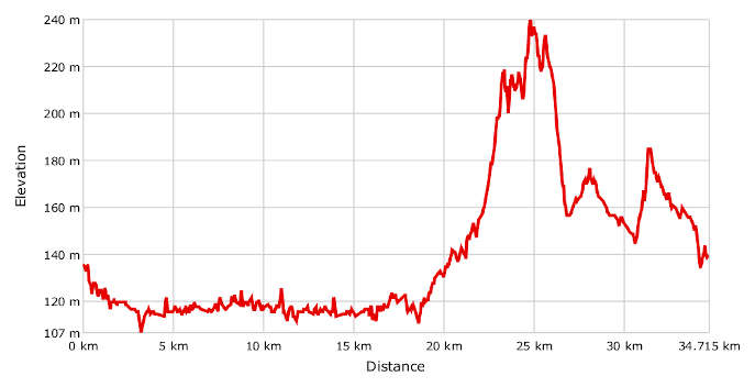
- Distance: 35 km
- Altitude difference: 133 m
- Total ascent: 354 m
- Total descent: 350 m
Natura 2000 is made up of Sites of Community Importance (SCIs) and is the European Union's main tool for protecting biodiversity. It is a network of ecological areas throughout the EU, set up to ensure the long-term preservation of natural habitats and rare and endangered animal and plant species at EU level.
The archaeological park of Asti is responsible for managing four SCIs.
The LIFE Sic2Sic project – 'through the Natura 2000 network in Italy by bike' – is run by ISPRA (a public environmental protection and research body), in collaboration with Ares 2.0 (a research and communications company), Enne3 (the business incubator at the University of Eastern Piedmont) and FIAB (an Italian cycling association). This project will show the public the importance of Natura 2000, thanks to the 6,000 km of cycle paths that will link 170 Italian sites in the network, split into 20 weekly trips in seven regions (Friuli-Venezia Giulia, Lazio, Umbria, Sardinia, Piedmont, Apulia and Sicily) that represent the range of natural habitats in Italy.
FIAB often suggests this route in Asti as a way to visit places of natural interest by bike. It is an easy route that everyone can enjoy, despite its length of 35 km, which may seem a lot for those who are not regular cyclists, but is over easy terrain.
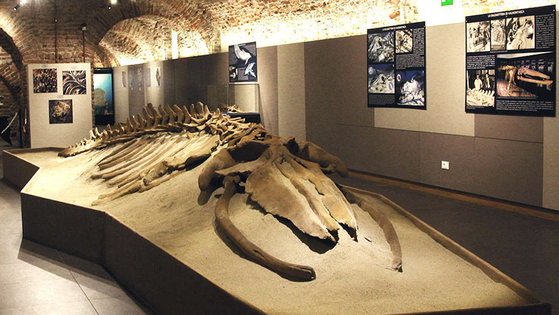
Start in Asti, near the archaeological museum in Piazza Fratelli Cairoli, worth a visit above all for an introduction to the route.
Head off in the direction of the river Tanaro, following the GPX track. Cross the river and take the first turning on your right. Go over the railway tracks and then left. After cycling about 8 km over roads and tracks, take the path on your right that leads to the river Tanaro again and the Stagni di Belangero ponds.
Here, past mining has left behind a mosaic of ponds, which have partly been reclaimed by plants, creating wet habitats, the marshy ponds known as the Stagni di Belangero. These are home to impressive animal and plant biodiversity, including the common spadefoot, a likeable but extremely rare ground-dwelling toad.
Recently, in April 2019, the site was made a regional nature reserve.
We suggest that you take a break to enjoy this wetland area.
The return to Asti is along a riverside path, then the same roads you arrived on. Take the bridge over the river Tanaro and turn left along the cycle paths and Viale Atleti Azzurri, Corso Torino and Corso XXV Aprile in the direction of Corso Sandro Pertini. Get away from the traffic onto Strada Valmorone until Viatosto. Carry on to Strada Mazzola then after 500 m take Strada Madonna di Viatosto until Bricco Giberto. Head towards the SCI of Valmanera, on the hilltops of Monferrato between 150 and 250 m above sea level. Its features are heavily influenced by its sandy substrate, which erodes to form rounded humps and little gills cut deep by little shady streams. The land here is rich in woodland plants. It is dominated by false acacia, with patches of chestnut and sessile oak, as well as woods of mixed English oak and hornbeam, which are of great importance in nature. Take the path through the area until you reach the park around the Villa Paolina, an environmental education centre. Along the first stretch of the path you can see bushes of rock rose, a rare Mediterranean shrub.
The Valmanera Oasi covers 10 hectares and all structures within it are owned by the municipal council of Asti but run by the WWF. You can cross the various nature trails through the woods, where there are boards and signs describing the main species of tree and shrub, used as a seedbed/nursery for reforestation work.
The way back is along the quiet minor road of Strada Valmanera, until the gates of the town, from where you return to your starting point in Piazza Cairoli.