- Bike: mtb
- Difficulty: *****
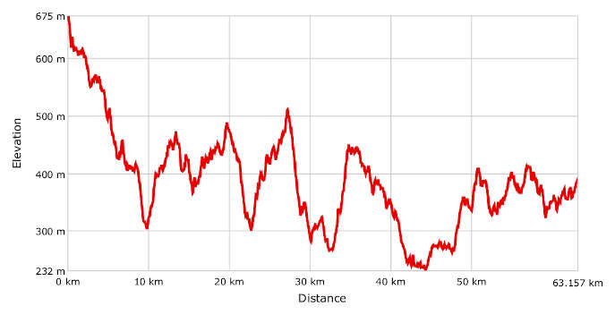
- Distance: 63 km
- Altitude difference: 533 m
- Total ascent: 1508 m
- Total descent: 2039 m
The Superga to Crea route, or SVC (Superga, Vezzolano, Crea), traces back to 1990 when Cesare Triveri, a member of CAI Casale Monferrato, mapped it out. Two new stretches were then added, from Moncalieri to Superga and from Crea to Casale Monferrato.
The bike route was officially inaugurated in 1999, then modified in 2006 by the cycling team then known as “ASD Montalero Bike, uno Spicchio di Monferrato”. Their aim was to make this route more exciting for mountain bike riding. They wanted the greatest technical challenge possible in the area covered by the route, over a reasonable distance that could be covered in a day by a cyclist in good shape.
That's why there are now two routes, one easier (signposted by CAI) and one harder (not signposted), which meet at some points.
Over many years until 2014, Montalero Bike organised major trips between the shrines of Superga and Crea, stopping at the abbey of Vezzolano and linking the city of Turin with Monferrato in the process.
In 2016, FIAB Monferrato Bike, in collaboration with their friends at Montalero Bike, came up with an interesting variation on the route.
Superga to Crea via the south was designed to avoid a car rally being held at the time. Since then, there have been two routes, the classic one through the mountains and the longer one with a detour to the south.
This is a description of the original, classic mountain bike route, plus a variation (see note 1).
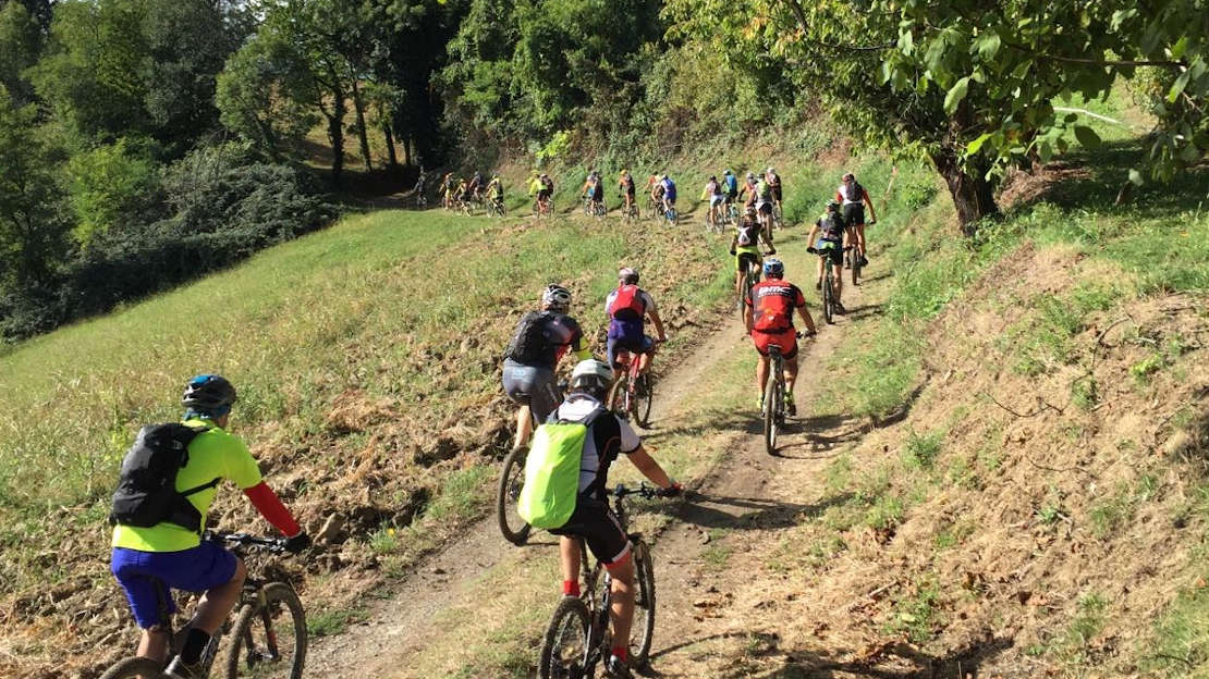
It starts near Turin, at the basilica of Superga, and ends at the shrine of Crea di Serralunga, in the province of Alessandria. It is a challenging route that has now become a classic day-long trip for cyclists in good shape from all over Piedmont.
The starting point is Piazzale della Basilica, 675 m above sea level. The first few kilometres are along Via Superga until Baldissero Torinese. Turn off here for Rivodora and take the stony track Strada della Croce towards Pavarolo. At the junction, near the sign, there is a very tricky downhill track. After a few short ups and downs you'll come down to the SP 122, where you should turn right onto Strada Collina Serra, a tarmac road with a lovely view and few cars. Go through Sciolze, which has cafés, restaurants and water houses.
Carry on to Cinzano, which has water points and public toilets. Keep pedalling on to Torrazza along a track through vineyards, then up a tarmac road and through Pogliano. Come off the tarmac and onto another track that will take you to Vezzolano Abbey near Albugnano in the province of Asti. This work of Romanesque and Gothic architecture is one of the most important medieval monuments in Piedmont and is worth setting aside time for.
Legend has it that the abbey was founded by Charlemagne, although the first document to mention the 'ecclesia' of Santa Maria in Vezzolano dates from 1095, well after his time.
After visiting the abbey, we recommend heading up to Albugnano, with its beautiful view point behind the church of San Rocco. On a clear day you can see the starting and ending points of the route with your naked eye.
Leave Albugnano on a downhill track through vineyards and fields, then climb a challenging track to Maroero.
Strada Serra, a mix of tarmac and track, will bring you to Tuffo. Take the tracks along the bottom of the valley to Murisengo, known as the truffle capital. You can refill your water bottle in the village square.
Carry on along a tarmac road now for Villadeati. This village is dominated by an opulent villa, widely referred to as the castle, that has been owned by the Feltrinelli family since the 1960s.
After a few ups and downs you'll reach the houses of Odalengo Piccolo and Castello di Pessine. After this castle, take a track with more ups and downs to reach the SP 18, then turn right and you'll arrive at Cascina Gigliola. Go down the track and on downhill through vineyards to Ponzano. Once you're back on the tarmac, pass the farm stay Cascina Zenevrea on your right, then take the SP 19 on your left to arrive at the shine of Crea.
Variation via the south
After leaving Strada della Croce, go right onto Strada del Toetto, then onto the track Strada Valentino, then Strada Caprigliano. Cross the SP 122 and take Via Ramea and Via Gassino to arrive in Andezeno, 306 m above sea level. Carry on along the SP 119 and get onto Via Borgo Cremera, then Strada del Lago di Arignano. The lake of Arignano was created in the 1840s, as a reservoir for collecting water used to irrigate the surrounding countryside. After the lake, go right, staying on the track, and you'll arrive in Moncucco Torinese. Stay on the SP 32b, then turn left onto the SP 16 and you'll arrive at the junction for Pogliano and get back onto the original route.
Superga to Crea, via the south
Route: mixed (tarmac, tracks), linear, medium distance
Length: 65 km
Total climb: 1,329 m
Total descent: 1,607 m
Time: 9.5 hours (including stops)