- Bike: trekking/mtb
- Difficulty: **
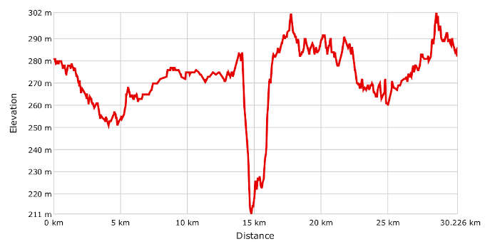
- Distance: 30 km
- Altitude difference: 91 m
- Total ascent: 257 m
- Total descent: 256 m
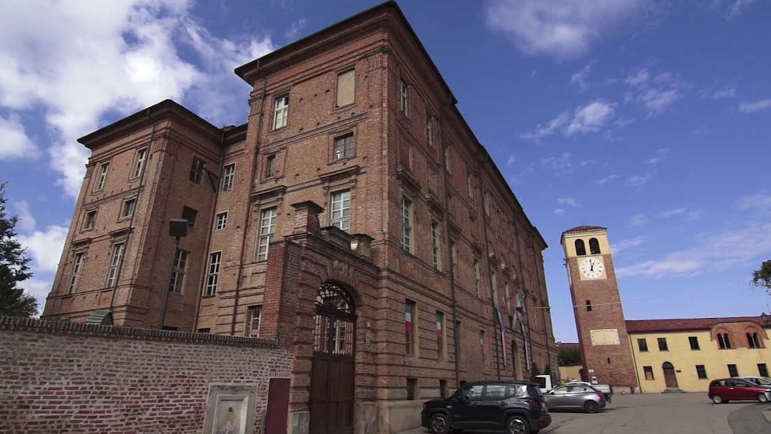
Not a lot of people know that Chieri is the town that gave the world blue jeans. A sort of blue fustian was already being produced there in the 15th century and exported via the port of Genoa, where the canvas was used for bags to carry ships' sails and to cover goods in the harbour. Some argue that the English name comes from 'bleu de Gênes' – 'Genoa blue'.
Start in Chieri, the 'town of a hundred towers', heading in the direction of Monferrato. Take the foot and cycle path to Riva presso Chieri. Once you reach the centre of Riva, you can't miss the chance to stop and walk under the medieval Torre Astense and then visit the parish church of Santa Maria Assunta, which is noteworthy for its exquisite interior elliptical dome, the work of architect Bernardo Vittone. Other real points of interest are the nearby Palazzo Grosso, with its decorated halls with their themed frescoes from the late 18th century, and Museo del Paesaggio Sonoro, which provides a fascinating journey through the sounds of traditional peasant music, bells ringing and animal noises.
Get back on your bike and head for San Giovanni di Riva. The stretch of road between Chieri and the village presents a good view of the Pianalto, the flat area that covers around 400 km² south-east of the Turin hills. Crossing the small village of San Giovanni, you can glimpse the house St Domenico Savio was born in, which has since become a place of spiritual interest and a pilgrimage site.
You can't get lost on the route from here on, thanks to the signs for the Cammino di Don Bosco along Strada Colombaro. These will lead you to Sentiero dei Cavalli, a cart track that winds through meadows and fields of maize before crossing the river Banna, still a stream at this point, and taking you into the province of Asti. Funnily enough, on this stretch you pedal right along the 45th parallel, halfway between the North Pole and the Equator.
Once you reach the village of Crivelle, near the big cross, leave the plain, going uphill on Strada Bosco del Conte. Before going downhill again, you should stop quickly to admire the view of Monferrato, with the proud silhouette of the basilica of Colle Don Bosco in the foreground.
Cross the stream and you'll reach the junction with Strada Costa del Pascolo. Leave the Cammino di Don Bosco, turning left in the direction of Buttigliera. This area is very interesting from a geological point of view. The grit you see on and at the side of the roads shows that the area was once covered by the sea that formed the Pliocene basin of Asti. It's not unusual to find fossils here.
A climb will take you to Buttigliera. This is the only challenging stretch of the route, but it's worth it for a rest at the top at the recently restored cemetery church of San Martino, which has a Romanesque structure.
The next stretch will take you to the centre of the village, where you can admire the tower of the parish church of San Biagio. At 52 m in height, it boasts the title of the highest bell tower in Monferrato.
It's now time for the homeward stretch. Take Via Principi del Piemonte, cross the ring road and take Strada Vecchia di Chieri, a long track over gentle hills, split halfway along by the SP 120 and surrounded by vineyards and orchards in rows.
The last part takes you onto a ridge, where you should slow down to fully appreciate the view of the hills of Chieri melting into the hills of the Po.
Go down of the ridge and turn left onto SP 121. After a quick descent, turn onto a track that will bring you to Strada Vecchia di Buttigliera. This in turn will take you back to where you started in Chieri, over a few kilometres of what feels like flat road.