- Bike: trekking
- Difficulty: ***
- Distance: 72,21 km
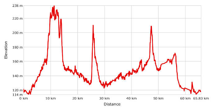
- Altitude difference: 124 m
- Total ascent: 541 m
- Total descent: 539 m
The route begins at the railway station in Asti, which can easily be reached along the urban cycle path, and follows the Asti–Nizza railway line at first. It carries on over the ridge of the Tiglione valley and passes through Cortiglione and on to Incisa Scapaccino. From here, it follows the river Belbo to Nizza Monferrato, town of Barbera wine.
From Asti station, go along Corso Savona, a road with a fair bit of traffic, and cross the river Tanaro. Turn left along a local road with little traffic, which quickly turns into a track. Now follow the Asti–Nizza Monferrato railway line. This stretch of the route includes some tracks.
Head up some steep but not too challenging slopes in the direction of Mongardino, to reach the valley ridge, where you can enjoy a very pleasant view. Go along the ridge to Montegrosso d’Asti. Once near the schools, take a short, easy downhill track that takes you to the bottom of the valley.
You are now in the Tiglione valley, which you will go down along quiet little roads – some tarmac, some tracks – until you reach Belveglio.
There's a pretty challenging climb here on the provincial road, with a 7–8% slope, but at 2 km, it's not too long. It will take you over the hill and on to Incisa Scapaccino. Here there is a track along the river Belbo, leading to Nizza Monferrato.
The return journey is less demanding, even if you do have to go over the Agliano Terme tunnel to get back to Montegrosso d’Asti and back onto the route you came. From here you take the SP 59, passing through Isola d'Asti and going slightly downhill back to the route's starting point.