- Bike: mtb
- Difficulty: ***
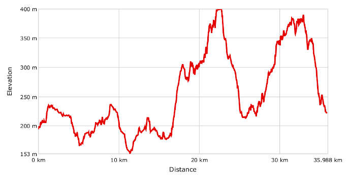
- Distance: 36 km
- Altitude difference: 247 m
- Total ascent: 728 m
- Total descent: 702 m
The route starts in Novi Ligure and ends in Serravalle Scrivia, passing through the hills where Gavi DOCG wine is made.
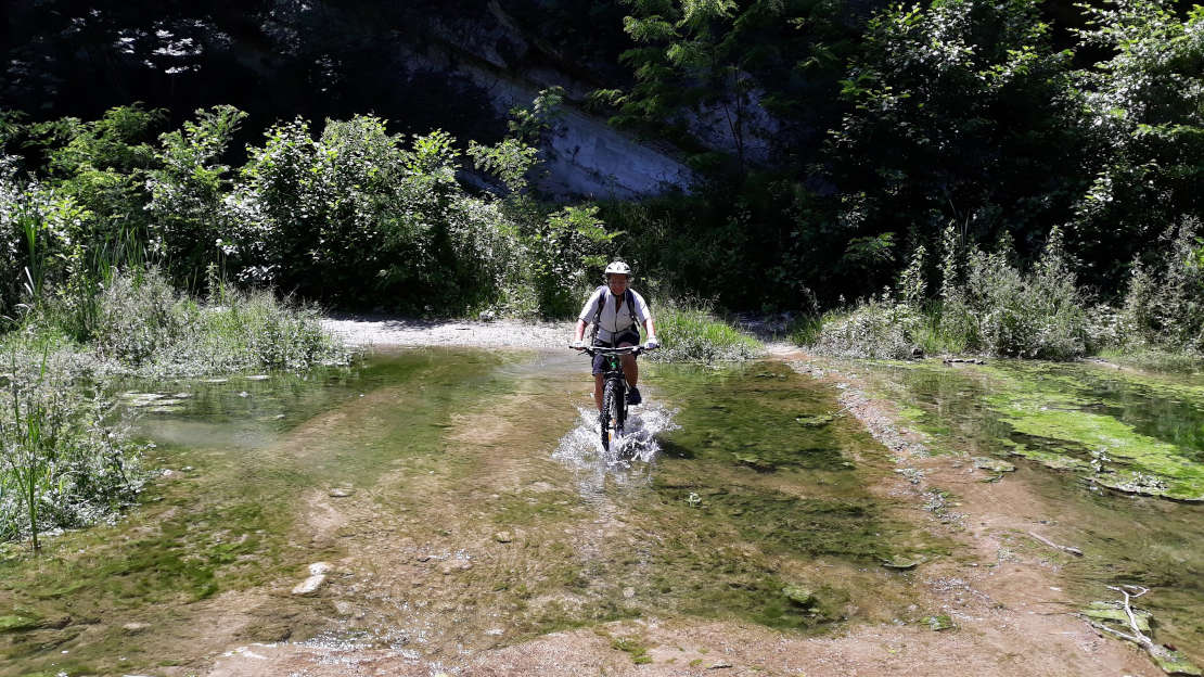
From Novi Ligure railway station, cross the whole town centre and arrive at the foot of the castle hill and continue straight up Salita Maina. At the top, carry straight on at the junction off the tarmac towards the Brenta Cucina Rossa restaurant. This is Strada Vecchia Pasturana, which becomes a track running through wheat fields after the restaurant. After reaching a junction with a road leading to a villa, turn right, quickly reaching the SP 156. Enter it on the left and follow it for about 800 metres. After passing an ancient church, turn left onto the first tarmac road you come to and right straight afterwards, down a track that enters a wooded area. At the end, come onto the tarmac road on the left that heads back up the little valley. The tarmac disappears shortly and you come to the Colline del Gavi golf course. The track continues for about 1.5 km over the course with some little ramps to climb. The tarmac returns and you come to a junction with a picnic area and fountain. Turn right, still on the tarmac, and start the climb to the top of the hill, heading alongside the golf course on the right. Carry straight on and start heading down. The first Gavi DOCG vineyards are here. This kind of scenery will account for nearly the whole route. Come up to Francavilla Bisio, which has a castle, and take a sharp left, still heading down. At the bottom, cross the provincial road and continue towards Biutta. When you come to the river Lemme, cross it over the bridge and continue on the left, heading back up the valley. The tarmac road rises on the left. After reaching some houses, the tarmac stops. This is hiking trail no. 390 to San Cristoforo, to be followed to the end. Pass the hamlet of Aureliana, continuing to head up the valley, off the tarmac. Shortly afterwards, turn left, taking you down alongside a vineyard. At the end of the vineyard, pass a small ditch and turn right, continuing on a track with vineyards on either side. Come out onto the tarmac road that heads up to San Cristoforo, but turn left instead of climbing, heading down until you’re by the bridge over the river Lemme. Don’t cross the bridge, but turn right onto a track that continues up the Lemme valley. Carry on until you come to a little pink house. Climb to reach it and take a sharp right, heading up the hillside among the vineyards. Carry on to a small wood, get back on the tarmac and very soon you'll see the first houses of San Cristoforo. When you reach the main road, keep climbing up to the centre of the village and its castle. Come down from San Cristoforo on the SP 176 but leave it at the bottom of the first downhill section, turning right at the sign for Via dei Campioni. Here, take a steep little tarmac road that climbs the hill sharply. At the left-hand bend, leave it to continue off the tarmac on the right, starting to head down. Turn left at the first junction, still off the tarmac, with the track going up and down along a ridge, passing over a methane pipeline. The track becomes a trail, which it is mostly possible to cycle along and more or less follows the ridge. Continue along it to the bottom of the shrine of the Madonna della Guardia di Gavi. The tarmac returns after you reach the first houses. Follow it to the top of the hill on which the shrine stands. After visiting the shrine, head down on the tarmac, cross the SP 168 and keep on down on the small tarmac road that then loses the tarmac, becomes a forest trail and finally turns into a path that you can cycle on, entering the wood. This continues to the bottom of the valley, opposite Gavi and its fortress. Reach the centre of Gavi by taking a track then a tarmac road. After visiting the village and possibly the fortress, take the SP 160 for Francavilla Bisio, but leave it immediately outside the village, heading off the tarmac on the right, onto a track that enters the Torrente Neirone Nature Reserve. This is a very attractive route, in a woody area shaped by its river and framed in some sections by steep cliffs. You also need to cross some really fun fords. The track now becomes a path. Some stretches are too steep for cycling, but it’s possible to cycle over most of them, and the beautiful location makes the effort worthwhile. Some parts of the path outside the wood might be overgrown in the spring and summer, but passing walkers and cyclists maintain a strip on which it’s possible to cycle. At a certain point, the path goes up on the left and becomes a forest trail that’s too steep for cycling. When you get to the top, the first vineyards appear and the climb becomes gentler and possible to cycle. When you come to a track, turn right onto it. This leads to the SP 162. Enter it on the right for about 30 metres, then turn right sharply on the dirt track that climbs to the top of the hill. Stay on the dirt track. At a certain point, it levels out and comes to some houses and tarmac. Leave this immediately, however, turning right. This track maintains its height initially then comes to the sign for hiking trail 299. Take this on the left in order to head down near the small Montei church. Head sharply down to Serravalle from here on trail 292A, first along a path, then a track. A final tarmac slope leads up to the first houses, and then it’s downhill all the way to the station.