- Bike: famiglia/mtb
- Difficulty: ***
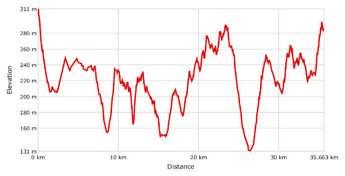
- Distance: 35 km
- Altitude difference: 180 m
- Total ascent: 721 m
- Total descent: 740 m
Start in Vignale Monferrato, in Piazza Callori, where you'll find the parish church of San Bartolomeo. It is the highest accessible point in the village. Behind the church, you can take advantage of the wide panoramic view to admire the hills that link Monferrato Casalese and Monferrato Astigiano.
Go first down Via Roma, then Via Cantamessa (SP 68). When you reach the large roundabout, go straight on in the direction of Casorzo, and turn off after 4 km for Altavilla.
After seeing the town, which has two important grappa distilleries, go down to the lower part of Altavilla. After 1 km, turn right before the cemetery for the village of Franchini. After about 2.5 km, turn right again on Piazza dei Lupi, following the road through the woods until you reach the village of Fubine. You will want to stop here to visit the area with its tall bell tower at the parish church of the Assunta. Leave the historic part of the village and go down on the provincial road (SP). Turn left at the crossroads and after about half a kilometre, turn right in the direction of Cuccaro. From the village at the small roundabout with the olive tree, turn right towards Alessandria then turn left after 200 m onto Via Aldo Moro. Now you pedal along a beautiful road with a panoramic view until you reach Lu, whose highest point is the soaring bell tower, one of the most picturesque spots in Monferrato. Leave Lu in the direction of Conzano, following the SP 66 down to Valle Grana, the valley, and then head back uphill. Once on Via Raineri, turn left just after the post office onto the SP 68 towards Camagna Monferrato. Just over 2 km away is Camagna Monferrato, which you will recognise by the valiant lantern sitting on top of the dome of the parish church of Sant' Eusebio. After stopping to see the village, carry on to Vignale Monferrato, the starting point of the route.